7 Ways Construction Project Managers Use Aerial Drone Data
Key Takeaways
- Aerial drone data gives project managers a reliable, repeatable view of every stage of construction without requiring manual site walks
- Drone surveys can produce orthomosaic maps, 3D models, volumetric calculations, and thermal reports, all from a single flight
- Progress monitoring, safety oversight, stockpile analysis, and stakeholder reporting are among the most practical and highest-value applications on active job sites
- Working with a direct-service provider (not a broker platform) ensures consistent quality and faster turnaround on deliverables
- FAA Part 107 certification and proper insurance are non-negotiable when hiring a drone service for commercial or industrial projects
Construction project managers are under constant pressure. Timelines slip. Subcontractors miss milestones. Stakeholders want answers yesterday. And most of the time, the biggest problems on a job site are the ones nobody saw coming because they were buried in a corner of the site nobody had eyes on.
That's where aerial drone data changes things.
Over the last several years, construction drone services have moved from a novelty to a genuine project management tool. The data they produce, things like orthomosaic maps, 3D site models, volumetric measurements, and thermal reports, doesn't just look impressive. It helps project managers catch problems early, document work accurately, and keep projects moving with fewer surprises.
Here are seven of the most practical ways construction PMs are putting drone data to work.
1. Pre-Construction Site Analysis and Planning
Before a single piece of equipment hits the ground, project managers need to understand what they're working with. Topography, drainage patterns, access points, surrounding structures, all of it affects how a project gets planned.
Drone surveys can capture detailed site data in a fraction of the time a traditional ground survey would take. The result is a georeferenced orthomosaic map or 3D surface model that gives the whole planning team an accurate baseline to work from. According to ASCE research on survey methods, aerial-based surveys consistently reduce the time and personnel required compared to conventional ground survey approaches.
That baseline matters throughout the project, not just at kickoff.
2. Progress Monitoring and Milestone Documentation
This is probably the most common use case, and for good reason.
Construction progress monitoring with drones gives project managers a consistent, repeatable aerial record of site activity. Fly weekly or bi-weekly. Compare this week's imagery to last week's. See exactly what's been completed, what's behind, and where the gaps are, without walking every inch of the site yourself.
The ability to compare progress over time is particularly valuable when managing multiple active builds or remote sites. At 1st Choice Aerials, we deliver progress monitoring data including high-resolution aerial imagery, annotated visuals, and time-lapse comparisons, organized so you can share them directly with your team or clients without any additional processing on your end.
The documentation also serves a legal function. When disputes arise over completed work, you've got timestamped aerial evidence. That's not a minor benefit.
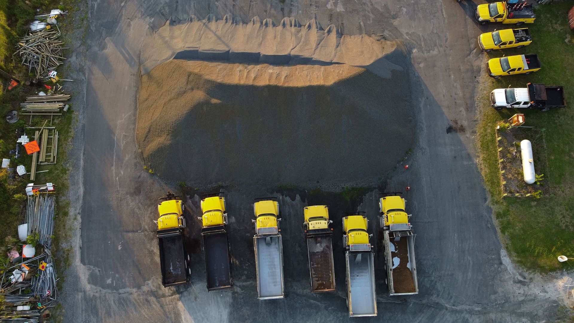
3. Volumetric Measurements for Earthwork and Stockpiles
Calculating earthwork volumes manually is slow, imprecise, and often requires stopping active site operations. Drone-generated 3D models let project managers calculate cut-and-fill volumes and stockpile quantities with much greater speed and consistency.
For projects with significant grading work or material management needs, this alone can justify the cost of regular drone flights. You're comparing actual earthwork elevations against design grades, verifying subcontractor billing, and catching discrepancies before they turn into disputes or change orders.
The FAA's guidelines on commercial UAS operations require that data collection like this be conducted by Part 107 certified pilots. When you hire a qualified provider, you're also ensuring the data meets the accuracy standards you actually need.
4. Safety Monitoring and Hazard Identification
Drones can go places people shouldn't have to.
Roofs, facades, elevated structural components, unstable slopes, areas near active excavation, these are all locations where sending a worker adds risk. An aerial inspection captures the same information without putting anyone in a dangerous position.
But it's not just about avoiding hazards. Drone overviews of an active job site can reveal unsafe conditions that are easy to miss from ground level. Improperly stored materials. Missing barriers around excavations. Congested traffic paths. From above, patterns become visible that nobody walking the site would notice.
Safety compliance documentation is another output here. Regular aerial records give project managers a defensible paper trail showing site conditions at any given point in time.
5. Quality Control and As-Built Verification
Here's a question worth asking: how often does your team catch construction errors after they've already been buried or built over?
Drone surveys during active construction let project managers compare in-progress work against design plans. Deviations in grading, misaligned structural elements, and off-spec earthwork are much easier to catch when you have accurate aerial data to compare against. Some teams integrate drone imagery directly into BIM platforms for this kind of plan vs. actual verification.
Catching these issues early is the difference between a quick correction and a costly rework. Research consistently shows that rework on commercial construction projects averages around 5% of total project cost and often runs higher. Drone-based quality control is one of the more direct ways to push that number down.
6. Stakeholder Reporting and Client Communication
Keeping owners, investors, and clients informed is part of the job. But producing meaningful updates takes time that most project managers don't have.
Aerial imagery makes that communication significantly easier. An orthomosaic map or annotated progress photo communicates site status more clearly than any written update. Stakeholders who aren't construction professionals can immediately see what's been done, what's in progress, and where the project stands.
At 1st Choice Aerials, we structure our deliverables specifically for this. Data arrives via Google Drive or your preferred method in a format that's ready to drop into a client presentation, stakeholder report, or investor update without any additional work from your team.
It's not just about looking professional. Clear visual documentation builds trust and reduces the back-and-forth that slows projects down.
7. Thermal Imaging for Construction Applications
This one often gets overlooked, but it's worth understanding.
Thermal drone inspections capture temperature variation data that's invisible to a standard camera. On construction sites, thermography is used to identify moisture intrusion in roofing systems, insulation gaps in building envelopes, and anomalies in electrical or mechanical installations, often before those issues become visible to the naked eye.
For commercial and industrial projects where building performance matters, thermal data during construction (not just after) can prevent expensive post-completion repairs. Catching an insulation gap during installation takes minutes to fix. Finding it after the wall is closed is a completely different problem.
Our team holds certifications in thermography in addition to FAA Part 107, which means we're not just collecting the data. We're delivering it in a way that actually tells you something useful.
What Most Competing Articles Miss
Most guides on drone data in construction focus on what drones can do in general terms. What they don't address is the difference between working with a direct service provider and going through a broker platform.
In the commercial drone industry, a significant portion of providers on broker platforms like Droners.io or FlyGuys don't actually perform the work. They win the job and subcontract it out, sometimes multiple layers deep. By the time someone shows up to fly your site, accountability has been diluted through several handoffs. Turnaround times stretch. Data quality varies. And if something's wrong with a deliverable, good luck knowing who's responsible.
That's the operational difference we see matter most on commercial construction projects. Direct client relationships, consistent pilots who know the site, and clear accountability from flight to final delivery. It's not a small distinction, especially on projects where the data drives real decisions.
Get Aerial Drone Data for Your Next Construction Project
Work With 1st Choice Aerials on Your Next Job Site
Whether you're managing a commercial development, tracking earthwork progress, or need reliable aerial data for stakeholder reporting, 1st Choice Aerials works directly with your team from day one. We provide construction drone services across Ohio and expanding coverage into Kentucky and Indiana, with fast turnaround and deliverables built for practical use.
No brokers. No subcontractors. Just accurate aerial data from a certified, insured team that understands what construction project managers actually need.
Request a quote for your project today.
Frequently Asked Questions
What types of deliverables do construction project managers receive from drone surveys?
Typical deliverables include high-resolution orthomosaic maps, 3D surface models, volumetric calculations, annotated progress imagery, and thermal inspection reports. The specific outputs depend on the project scope and what decisions the data needs to support.
How often should drones be flown on an active construction site?
It depends on the project's complexity and reporting requirements. Weekly or bi-weekly flights are common for active builds where progress tracking and stakeholder updates are priorities. Some projects run monthly flights for documentation purposes only.
Do construction drone operators need to be FAA certified?
Yes. Commercial drone operations in the United States require FAA Part 107 certification. Providers should also carry liability insurance appropriate for commercial and industrial job sites. Always confirm both before hiring.
Can drone data be used for subcontractor billing and dispute resolution?
Yes. Volumetric measurements from drone surveys and timestamped progress imagery are frequently used to verify completed work quantities and support or dispute subcontractor billing claims. Accurate aerial records provide a documented baseline that both parties can reference.
How accurate is drone survey data for construction use?
When captured using enterprise-grade equipment with RTK (real-time kinematic) positioning, drone surveys can achieve centimeter-level horizontal and vertical accuracy. This makes them suitable for earthwork verification, grade comparison against design plans, and similar precision-dependent applications.
What's the difference between a drone mapping deliverable and a regular aerial photo?
A regular aerial photo is an image. A drone mapping deliverable, specifically an orthomosaic, is a georeferenced, distortion-corrected composite assembled from hundreds of overlapping images. It can be measured, scaled, and used for spatial analysis in ways a standard photo cannot.
How do construction teams receive and use drone data after a flight?
Data is typically delivered via cloud storage or a file transfer method agreed upon before the project. Deliverables are formatted for use in project management platforms, BIM software, or shared directly with stakeholders without additional processing required.