How Accurate Are Drone Maps Compared to Traditional Survey Methods?
Key Takeaways
- With RTK or PPK correction systems, drone maps can achieve 1–5 centimeters of horizontal accuracy, which meets ASPRS standards for most commercial and construction applications.
- Traditional ground surveys offer slightly higher precision at the millimeter level, making them better suited for legal boundary work and highly specialized engineering tasks.
- For large sites, drone mapping covers far more ground in far less time, with some drone workflows replacing multiple days of field work with a single flight.
- The right method depends on your project's accuracy requirements, site size, terrain, and how often you need updated data.
- A professional drone team with the right equipment and workflow can produce data that's genuinely actionable for construction planning, progress tracking, inspections, and site documentation.
This question comes up a lot in commercial and construction circles, and it's a fair one. If you're considering drone mapping for a project in Ohio, you want to know whether the data is actually reliable before you make decisions based on it. So let's get into the real answer, because it's more nuanced than a simple yes or no.
What "Accuracy" Actually Means in Mapping
Before comparing methods, it helps to understand what accuracy means in this context. In mapping and surveying, accuracy refers to how close a measured position is to the true real-world location. It's usually described in terms of horizontal accuracy (X/Y position on a flat plane) and vertical accuracy (elevation), and it's measured using root mean square error (RMSE), a statistical method endorsed by the American Society for Photogrammetry and Remote Sensing (ASPRS).
Vertical error is typically larger than horizontal error in both drone and traditional methods, so it's worth asking your data provider about both dimensions for any project with elevation-sensitive requirements.
How Traditional Survey Methods Work
Traditional land surveying uses equipment like total stations, RTK GPS receivers, and theodolites to measure individual points on the ground. Surveyors physically walk the site, set up instruments at known control points, and collect precise measurements one location at a time. This produces millimeter-level accuracy, which is why it's the required method for legal property boundaries, easements, and certain engineering projects with zero tolerance for positional error.
But that level of precision comes with a real cost in time and money. A ground crew surveying a 20-acre site might need one to two weeks in the field. And for large, complex commercial or industrial sites, that timeline can stretch further.
How Drone Mapping Works
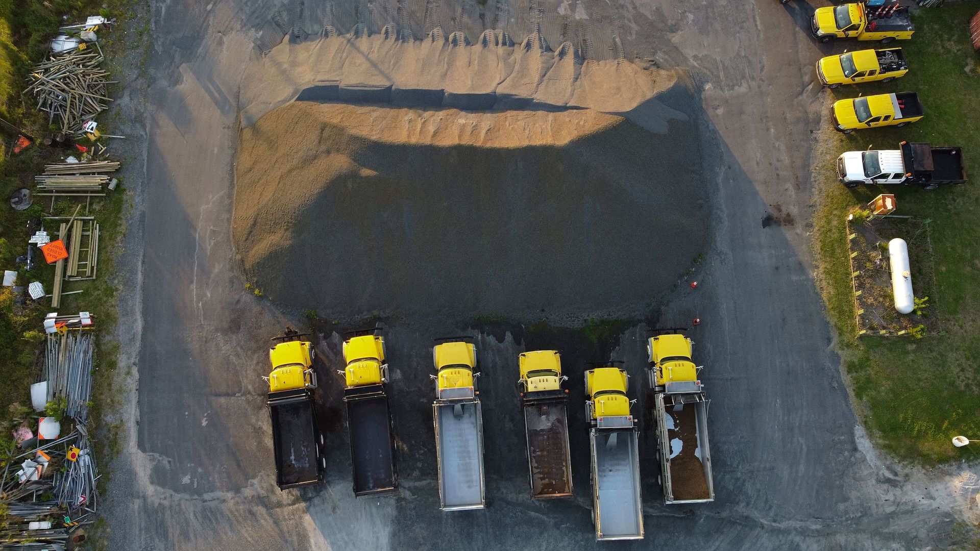
Drone mapping, sometimes called photogrammetry, works differently. A drone flies a planned grid pattern over the site, capturing hundreds of overlapping high-resolution images. Those images are then processed through specialized software to generate orthomosaic maps, digital surface models, and 3D point clouds.
The accuracy of the final product depends almost entirely on how the drone is equipped and how the flight is set up. That's the part most articles skip over, but it's the part that matters most.
The RTK and PPK Difference
Standard GPS alone can drift by several meters, which isn't close to survey-grade. That's why professional drone operations use either RTK (Real-Time Kinematic) or PPK (Post-Processed Kinematic) correction systems. RTK applies corrections to the drone's position in real time during the flight by connecting to a ground base station or a network correction service. PPK applies those corrections after the flight during data processing.
Both methods achieve centimeter-level positioning. According to McKissock Learning, drone photogrammetry can reach 1 to 5 centimeters of accuracy under good conditions, though that result depends heavily on proper survey design, precise control layout, and thorough data validation. The ASPRS Positional Accuracy Standards for Digital Geospatial Data are the benchmark used to evaluate whether a given drone dataset meets professional-grade requirements for commercial use.
Ground Control Points
In addition to RTK or PPK, many drone surveys use Ground Control Points (GCPs). These are physical markers placed at known, surveyed positions on the ground before the flight. When GCPs are included alongside RTK correction, accuracy typically improves to 1 to 3 centimeters horizontally and 2 to 5 centimeters vertically. That's on par with what you'd get from a traditional RTK GPS survey for most mapping and construction applications.
Side-by-Side Comparison: What Really Differs
So if the accuracy is often comparable, what's the actual difference? A few things.
Coverage speed. Traditional ground crews might cover 10 acres in a day. A drone can map over 100 acres in under an hour. For large commercial or industrial sites, that gap is significant.
Data density. A traditional survey collects hundreds of individual measurement points. A drone flight produces millions. That density enables detailed 3D modeling, volume calculations, and surface analysis at a level that ground-based methods simply can't match efficiently.
Cost. Drone surveys typically cost 50 to 75 percent less than traditional ground surveys for sites over five acres. A traditional topographic survey on a 20-acre site might run $15,000 to $30,000 and take one to two weeks. The same site done by drone generally costs $3,000 to $6,000 and can be completed in a single day.
Repeatability. This is where drone mapping genuinely outperforms traditional methods for construction and commercial clients. You can fly the same site monthly, biweekly, or even weekly to track progress. Traditional surveying at that frequency is impractical for most budgets.
Legal and boundary work. Traditional surveying still holds the edge here. For legal property boundaries or projects requiring a licensed surveyor's stamp, a traditional ground crew or a hybrid approach is usually necessary.
Where Drone Mapping Makes the Most Sense
For the kinds of projects we work on at 1st Choice Aerials, drone mapping consistently outperforms traditional methods in practical terms. Think about a commercial construction site that needs monthly progress documentation, stockpile volume calculations, grading verification, and a visual record for stakeholders. A ground crew doing that work repeatedly is expensive, disruptive to site activity, and slow to turn around.
Our drone mapping services in Ohio are built around these exact use cases. We use structured flight planning and enterprise-grade drone technology to capture high-resolution imagery that processes into orthomosaic maps and 3D models with the positional accuracy that construction planners, property owners, and industrial clients actually need.
For construction teams specifically, the combination of our construction drone services and regular site mapping gives project managers something they can't get from periodic ground surveys: continuous, accurate visibility into what's happening across the full site at any given time.
The Honest Answer: It Depends on What You're Measuring
If you need to place a legal boundary marker, drone mapping alone won't get you there. That's not a knock on the technology. It's just the right tool for the right job.
But if you need accurate site data for construction planning, volume analysis, progress monitoring, or documentation across a large commercial or industrial site? Drone mapping with a properly equipped system and professional workflow is not just accurate enough. In many cases, it gives you better data, faster and at a fraction of the cost.
And here's something the comparison articles rarely mention: the question isn't just whether the numbers match. It's whether the data is delivered in a format your team can actually use within a timeline that supports your project. A highly precise survey that takes three weeks doesn't help a construction manager who needs updated volume calculations by Monday.
Our team at 1st Choice Aerials includes professionals with backgrounds in construction, aviation, engineering, and public safety. We don't subcontract through broker platforms or pass your project through middlemen. That means clear communication, consistent quality, and deliverables typically ready within 24 to 48 hours. For ongoing site documentation, we also offer recurring monthly mapping plans so your team always has a current aerial record to work from.
If your project involves commercial inspections or thermography alongside mapping, we can bundle those into a single mobilization to maximize value.
Ready to See What Drone Mapping Can Do for Your Site?
If you're working on a commercial, industrial, or construction project in Ohio and need accurate aerial data you can act on, we'd love to talk through your options. Contact 1st Choice Aerials to request a quote or ask us what's possible for your specific site and timeline.
Frequently Asked Questions
How accurate is drone mapping for construction projects?
When equipped with RTK or PPK correction systems, drone maps typically achieve 1 to 5 centimeters of horizontal accuracy. For most construction applications including grading verification, volume calculations, and progress tracking, this is well within acceptable tolerances and meets ASPRS standards for professional-grade geospatial data.
Can drone maps replace a licensed land survey?
Not for legal boundary work. If you need a stamped survey for permitting, property line determination, or legal documentation, a licensed surveyor is required. But for site planning, construction monitoring, inspection documentation, and aerial mapping, drones provide reliable, usable data without that requirement.
What is the difference between RTK and PPK in drone mapping?
Both are GPS correction methods that bring positional accuracy down to centimeter level. RTK applies corrections in real time during the flight, while PPK applies them after the flight during data processing. RTK is faster to deliver. PPK can be more reliable in areas with connectivity issues. Both are appropriate for professional commercial mapping.
How does drone mapping compare to traditional surveying in terms of cost?
For sites over five acres, drone surveys generally cost 50 to 75 percent less than traditional ground surveys. A 20-acre site that might cost $15,000 to $30,000 to survey traditionally can typically be drone-mapped for $3,000 to $6,000, often in a single day.
What deliverables do I get from a drone mapping project?
Professional drone mapping projects typically produce orthomosaic maps (georeferenced 2D aerial images), 3D surface models, digital terrain models, point clouds, and measurement-ready imagery. Depending on your project needs, you can receive these in formats compatible with GIS software, CAD platforms, or standard project management workflows.
Is drone mapping accurate enough for stockpile volume calculations?
Yes. With properly calibrated RTK equipment and a well-planned flight, drone mapping produces dense enough point cloud data to calculate stockpile volumes with accuracy that's more than sufficient for earthworks and construction site management. It's also far faster and more repeatable than manual measurement methods.
How often should a construction site be drone-mapped?
It depends on the pace of the project. Active construction sites often benefit from monthly or biweekly flights to track progress, catch discrepancies early, and maintain a visual record for project management and stakeholder reporting. Some clients on fast-moving projects opt for weekly captures during critical phases.