
Revolutionizing Site Management with Drones in Dayton Ohio
You're standing on a sprawling job site. The air is filled with the sounds of machinery and the morning buzz of activity.
But you can't shake that nagging feeling in the back of your mind. Are things on schedule?
Are materials where they should be?
Getting a complete picture of your project can feel impossible.
This is where site management with drones in Dayton Ohio changes everything, giving you eyes in the sky and complete control.
Instead of guessing, you get data-driven answers.
Ready to view your construction project from new heights?
Contact 1st Choice Aerials today to schedule your aerial photography, inspection, or thermal imaging service!
On This Page:
What Does Drone Site Management Actually Mean?
Drone site management uses small, unmanned aerial vehicles equipped with high-resolution cameras and advanced sensors to fly over your project.
This could be a construction site, a commercial property, a farm, or a large industrial facility.
The drone captures massive amounts of data from the air using sophisticated aerial imaging techniques.
This data is then turned into useful information, like detailed maps, 3D models, and progress reports, removing guesswork from managing your site.
The Old Way of Managing a Site Is Slow and Expensive
Remember how site management used to work?
It often still does for many.
You'd have managers walking the site with a clipboard, taking notes and photos.
If you needed an overhead view, you might have to hire an expensive helicopter or airplane.
Getting accurate measurements for large piles of materials was a slow, sometimes dangerous job for surveyors on the ground, who had to manually place ground control points.
This old way of doing things is not just slow; it's filled with opportunities for human error.
A misplaced decimal or a missed problem area could lead to serious budget overruns.
Information would take days or weeks to get to the people who needed it most.
It was the best they had at the time, but technology has moved on.
A New Era: How Drones Are Different
Now, picture this instead.
A certified drone pilot arrives at your Dayton location.
Within minutes, the drone is in the air, methodically scanning your entire property and collecting high-quality aerial photos.
Instead of a handful of photos from the ground, you get thousands of high-definition images.
These images are stitched together using sophisticated photogrammetry software.
You now have an interactive digital model of your site on your computer.
You can zoom in, take measurements, and see progress from last week compared to this week.
The information is available almost instantly.
It's safer, faster, and much more accurate than the old methods.
Your Top Guide to Site Management with Drones Dayton Ohio
You're likely wondering how this technology can specifically help your business.
It's not just about cool pictures; it's about making your job easier and your company more profitable.
Let's look at how different industries in the Dayton area are using drones to get ahead.
Construction Progress Monitoring

Construction projects are complicated, and keeping track of every moving part is a massive challenge.
Drone services give general contractors and project managers a complete overview of the site on a regular basis.
You can use these regular flights to track progress against your plans and improve quality assurance.
You can quickly see if earthwork is on track or if subcontractors are falling behind.
This early detection saves a huge amount of time and money.
According to a report by Autodesk, a construction software company, about 52% of rework is caused by poor project data and miscommunication, a problem that drones directly help to fix.
This constant stream of data allows for better collaboration between the field and the office.
Stakeholders can view progress from anywhere in the world. This transparency builds trust and keeps everyone on the same page.
Commercial Real Estate
Are you a real estate developer or broker?
Imagine being able to show potential investors or tenants a stunning aerial view of a property through professional aerial photography.
Drones create high-impact marketing videos and photos that show a property's true scale and its surrounding area.
But it goes beyond marketing. For property management, unmanned aerial vehicles can be used to inspect roofs and building exteriors safely.
This saves you from hiring expensive crews and equipment for simple inspections and documents the condition of your assets over time.
Agriculture in the Miami Valley
Farming is all about efficiency. Drones fitted with special multispectral sensors can fly over fields to check crop health.
They can identify areas that are struggling with irrigation issues, pests, or nutrient deficiencies.
This information allows farmers to apply water, fertilizer, or pesticides exactly where they are needed.
This precision agriculture approach saves money on resources and boosts crop yields.
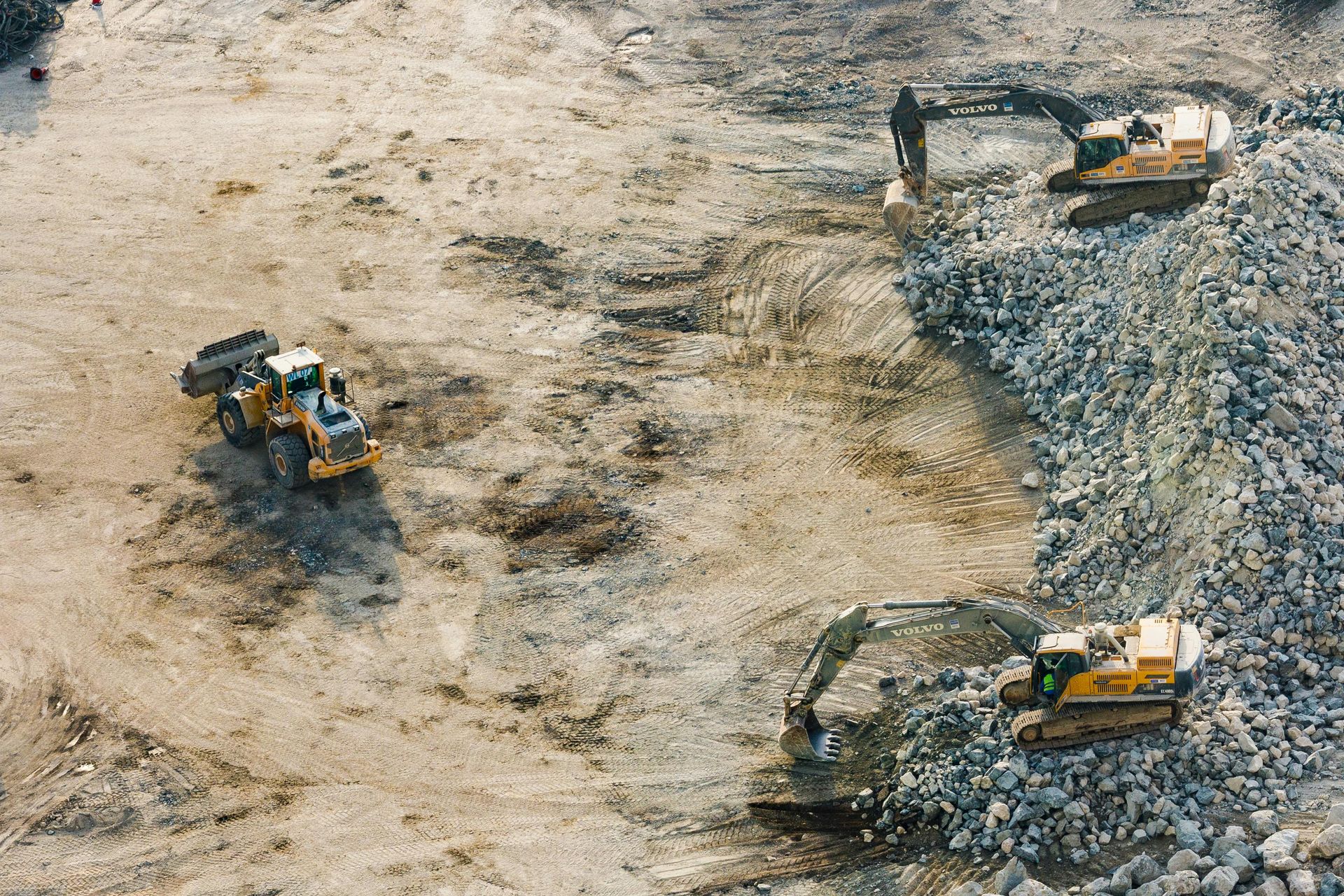
Stockpile and Volumetric Measurements
If your business deals with aggregates, sand, soil, or any bulk material, you know how hard it is to measure inventory.
Traditional survey methods are slow and can halt operations. Drones make stockpile measurement fast and accurate.
A quick drone flight can produce a 3D model of your stockpiles.
Software can then calculate the volume with an accuracy that's hard to achieve on the ground.
You get quick, reliable data for inventory management and accounting.
How Does The Whole Process Work?
You might be thinking this sounds complicated, but working with a professional drone service provider is a very straightforward process.
We've broken it down into a few simple steps so you know exactly what to expect.
- Initial Consultation: We'll start by talking about your project. What are your goals? What information do you need to make better decisions? We want to understand your challenges completely.
- Flight Planning: Based on our conversation, we create a detailed flight plan. This plan follows all Federal Aviation Administration (FAA) rules and includes a review of regional airspace surveillance data. Safety is always the top priority, and the plan outlines what data will be collected.
- On-Site Data Capture: A licensed drone pilot comes to your Dayton location. They will perform a pre-flight safety check, establish ground control for accuracy, and then conduct the flight according to the plan. This part is usually quite fast, minimizing any disruption to your operations.
- Data Processing: This is where the magic happens. The raw data from the drone, which can be thousands of images, is uploaded to powerful processing software. It's then transformed into the final products you need, such as orthomosaic maps, 3D point clouds, or digital elevation models.
- Delivery and Review: You get easy-to-understand reports and access to your data through a simple web portal. We can walk you through the information. We'll show you how to use it to track progress, verify work, and plan your next steps.
Finding the Right Partner in Dayton
So, how do you pick the right company for your project?
Not all drone service providers are created equal.
Look for a team that has specific experience in your industry, offering more than just simple aerial photos.
A company that understands construction has different skills than one that focuses on real estate marketing.
Ask to see examples of their previous work.
A professional team will be able to show you detailed reports and maps they have created for other clients.
Dayton is a hub for aerospace innovation, with companies pushing the boundaries of technology for uncrewed aircraft systems and airspace protection.
Look for providers that offer market-leading solutions and stay current with technology.
For example, local company Cal Analytics was awarded an AFWERX SBIR Direct-to-Phase II contract focused on deconfliction technology for providing air traffic services in tactical environments, showing the high level of expertise in the region.
Make sure any company you consider has the proper FAA certification and is fully insured.
This protects your small business and your property.
You should feel comfortable asking them questions about their process and safety procedures before making a decision.
Conclusion
Running a complex project in the Dayton area has its share of challenges.
You are constantly juggling schedules, budgets, and teams to keep things moving forward.
Relying on outdated methods to track your progress just adds more stress and opens the door for costly mistakes.
This is why making the switch to site management with drones in Dayton Ohio is such a powerful move for local businesses.
It provides the clarity and hard data you need to make smart, proactive decisions.
This puts you firmly in control of your project's outcome from start to finish.
Ready to view your project from new heights?
Contact 1st Choice Aerials today to schedule your aerial photography, inspection, or thermal imaging service!


