
Understanding the Cost of Commercial Drone Mapping Services in 2025
Thinking about using drones for your business in 2025?
It’s a smart move, but figuring out the cost of commercial drone mapping services can feel like a puzzle.
Drones are changing how we get work done, from building sites to farms, and knowing what you’ll pay is key.
This article breaks down what goes into those prices, so you know what to expect and can make good choices for your projects.
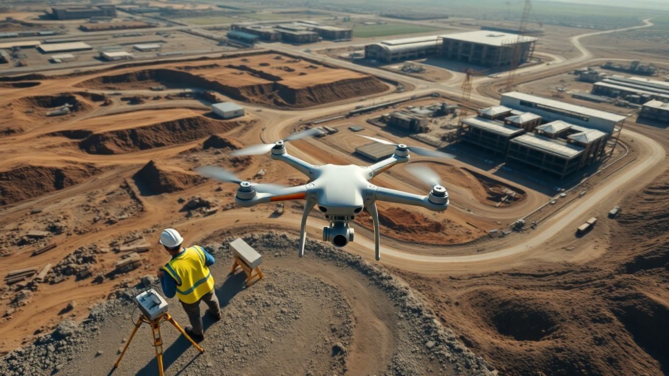
Ready to view your construction project from new heights?
Contact 1st Choice Aerials today to schedule your aerial photography, inspection, or thermal imaging service!
On This Page:
Key Factors Influencing Drone Service Pricing
Several big things affect how much you'll pay for drone mapping.
The complexity of the job is a major one.
Are we talking about a simple aerial photo of a construction site, or a detailed 3D model of a large industrial facility?
The more detailed and extensive the mapping, the more time and resources are needed, which naturally bumps up the price.
The type of data you need is also important.
High-resolution imagery, thermal scans, or LiDAR data all require different equipment and processing, each with its own cost.
- Geographic Location: Where the work is done matters. Flying in remote areas or areas with difficult terrain can take more time and planning than mapping a flat, easily accessible field.
- Required Accuracy and Detail: Projects needing very precise measurements or highly detailed outputs will cost more than those requiring general overview data.
- Turnaround Time: If you need the data back in a hurry, expect to pay a premium for expedited processing and delivery.
The drone mapping industry is growing fast.
More businesses are seeing the benefits, which means more companies are offering these services.
This increased competition can sometimes help keep prices in check, but it also means providers are investing in better tech and training to stand out, which can add to their costs.
The Impact of Market Growth on Service Costs
As more industries adopt drone technology, demand for mapping services increases.
This expansion means providers might charge more for specialized services or in high-demand areas.
However, as the market matures, there's also a push towards more standardized pricing and efficiency.
New technologies are making data collection faster and cheaper, which could eventually lead to lower costs for some services.
It's a balancing act between increased demand and technological advancements.
Core Cost Components In Drone Service Pricing
When you're looking at the price tag for drone mapping services, it's not just about the pilot's time in the air.
Several underlying costs go into making sure you get accurate, usable data.
Understanding these components helps explain why prices can vary so much and what you're actually paying for.
Equipment Investment And Maintenance
The drone itself is a big one, obviously.
High-end drones with advanced sensors and cameras aren't cheap.
Think of it like buying a professional camera versus a point-and-shoot; you get what you pay for in terms of image quality and capabilities.
But it doesn't stop there.
These machines need regular check-ups, software updates, and sometimes repairs.
Batteries degrade, propellers get dinged, and sensors can get out of calibration.
All of this adds up, and providers have to factor it into their rates to keep their fleet in top shape.
Skilled Labor And Training Expenses
It takes more than just knowing how to fly a drone to do professional mapping.
You need pilots who understand flight planning, airspace regulations, and how to capture data effectively for mapping purposes.
Then there's the team that handles the data after it's collected – processing, analyzing, and creating the final deliverables.
These folks need specialized training, and keeping their skills sharp with ongoing education is a must.
This isn't a hobbyist operation; it's a professional service requiring skilled individuals.
Insurance, Licensing, And Operational Permits
Flying drones commercially comes with responsibilities.
Providers need to carry insurance to cover potential accidents or damages, which can be a significant ongoing expense.
Depending on where and how the drone is flown, various licenses and permits might be required.
For instance, flying in controlled airspace or at night often necessitates special waivers from aviation authorities.
Obtaining these approvals takes time, effort, and sometimes additional fees, all of which are part of the cost of doing business legally and safely.
This is why you'll see hourly rates that reflect these overheads.
Pricing Structures For Drone Mapping Projects
When you're looking to hire a drone mapping service, figuring out how they charge can feel a bit like a puzzle.
It's not just about the final price tag; it's about understanding the different ways providers structure their fees.
This helps you budget better and makes sure you're getting what you pay for.
The way a company prices its services often tells you a lot about their approach to projects and client relationships.
Let's break down the common ways drone mapping projects are priced.
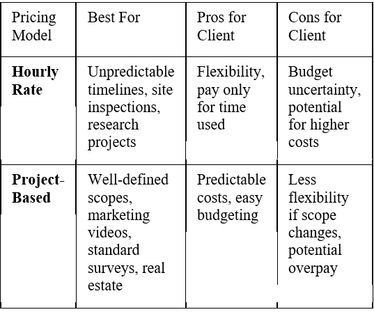
Hourly Rates Versus Project-Based Fees
This is probably the most common split you'll see.
On one hand, you have hourly rates.
This means you pay for the actual time the drone pilot and their equipment are working on your project.
It's flexible, especially if your project scope isn't perfectly defined from the start.
Think of it like hiring a contractor by the hour – if unexpected issues pop up or the job takes longer than anticipated, the cost goes up.
Rates can swing pretty widely, maybe from $150 to $400 an hour in 2025, depending on the drone, the pilot's skill, and where you are.
Then there are project-based fees. Here, the provider gives you a single, fixed price for the entire job.
This is great for budgeting because you know the total cost upfront.
It works best for projects with clear goals and deliverables, like a standard real estate aerial photo shoot or a simple site survey.
It's straightforward for both you and the provider.
However, if the project scope creeps or unforeseen complications arise, the provider might lose money unless they've built in a good buffer.
Here's a quick look at when each might be a better fit:
Subscription And Retainer Models
These models are becoming more popular, especially for clients who need ongoing drone services.
Instead of paying for each individual job, you pay a recurring fee – monthly or annually.
This is fantastic for businesses that require regular updates, like construction companies monitoring progress on a long-term build, or agricultural operations needing frequent crop health assessments.
It often comes with a set number of hours or services per period, and sometimes includes priority scheduling or discounted rates for longer commitments.
It really helps build a consistent relationship with a drone service provider and ensures you have that capability ready when you need it.
For example, a company might sign a retainer for weekly site surveys, which is much simpler than booking each one individually.
This approach is also great for specialized services like regular infrastructure inspections, where consistent data collection is key.
You can find providers who offer these packages for various needs, from basic aerial photography to complex drone surveying data collection.
Per-Mile Or Area-Based Pricing Strategies
Sometimes, pricing isn't about time or a single project scope, but about the physical space covered.
This is common for large-scale mapping or surveying projects.
For instance, a provider might charge a certain amount per acre or per square mile mapped.
This makes sense when the terrain's complexity or the sheer size of the area is the main driver of cost.
It's a straightforward way to scale the price with the project's physical footprint.
You might see this for large agricultural fields, extensive land development projects, or regional environmental studies.
Industry-Specific Pricing For Drone Services
Let's cover some specifics of industry-specific pricing for drone services.
Different sectors have unique needs and challenges, which naturally influence how drone services are priced.
Let's dive into some of the most common ones.
Construction and Infrastructure Mapping Costs
When it comes to construction and infrastructure projects, drone mapping isn't just a fancy add-on; it's becoming a standard tool.
Think about tracking progress on a big building site, checking the condition of a bridge, or surveying land before any digging starts.
The costs here can really vary.
A simple aerial photo of a small site might be a few hundred dollars, but a detailed 3D model of a large construction project, updated weekly, could run into thousands per month.
Factors like the area size, the required detail (e.g., specific measurements or material identification), and how often you need updates all play a big role.
For instance, a one-time topographic survey for a new development might cost between $1,500 and $5,000, depending on the acreage.
Regular progress monitoring, however, might be priced at $50-$150 per acre per month, with additional fees for detailed reports.
The complexity of the terrain and the need for specialized sensors, like thermal cameras for detecting heat loss in buildings, will also push prices up.
You can find more about the general drone market in the Global State of Drones 2025 report.
Inspection Services Pricing
Drone inspections are a game-changer for hard-to-reach areas, such as wind turbines, power lines, and tall buildings.
Instead of expensive scaffolding or dangerous climbs, a drone can get up close safely.
Pricing for these services usually depends on the type of asset being inspected, the number of assets, and the complexity of the inspection.
A basic visual inspection of a few cell towers might cost $500-$1,000 per tower.
However, a detailed inspection of a large wind farm, requiring specialized cameras (like thermal or high-resolution zoom) and detailed reporting on potential defects, could easily cost $10,000 or more for the entire farm.
The time it takes to fly, collect the necessary data, and process it into a usable report is a significant cost driver.
Some providers might charge per asset, while others might use an hourly rate for more complex, custom inspections.
It’s not just about flying the drone; it’s about the specialized knowledge to spot issues and the detailed analysis that follows.
Public Safety and Emergency Response Rates
In public safety, drones are used for everything from search and rescue operations to accident scene reconstruction and monitoring crowd events.
The pricing here is often different because these situations can be urgent and unpredictable.
For emergency response, many agencies have contracts or retainers with drone service providers.
These contracts might guarantee a certain level of availability and response time, often with a monthly fee.
For example, a retainer might be $2,000-$5,000 per month for guaranteed availability, with additional hourly charges when a drone is actually deployed, perhaps $200-$400 per hour.
For non-emergency services, like accident scene mapping, pricing might be project-based, similar to construction mapping, but with a premium for the speed and accuracy required.
The value here is immense, providing critical information quickly to save lives and resources.
It’s a service where reliability and rapid deployment are paramount, and that comes at a price.
Wrapping It Up: What to Expect for Drone Mapping Costs
So, when you're looking at the price tag for commercial drone mapping services in 2025, remember it's not just about the drone itself.
You're paying for skilled pilots, fancy software, insurance, and all the behind-the-scenes work that goes into getting you accurate data.
Prices can really jump around depending on what you need – a quick survey of a small field is way different from mapping a huge construction site.
It’s all about finding that sweet spot where you get the information you need without breaking the bank.
Talking openly with providers about your project and what you expect will help a lot in getting a fair price and a job well done.
Ready to view your project from new heights?
Contact 1st Choice Aerials today to schedule your aerial photography, inspection, or thermal imaging service!


