
Drone Aerial Surveys for Civil Engineering Frankfort KY
Drone surveys are revolutionizing the management of civil engineering projects across Frankfort, Kentucky.
Thanks to these powerful devices, engineers now have a full overhead view of building locations, allowing them to plan and carry out their work with impressive accuracy.
If you are involved with civil engineering in the capital of the Bluegrass State, understanding this technology is essential for staying competitive.
Ready to view your construction project from new heights?
Contact 1st Choice Aerials today to schedule your aerial photography, inspection, or thermal imaging service!
On This Page:
What Are Drone Aerial Surveys?
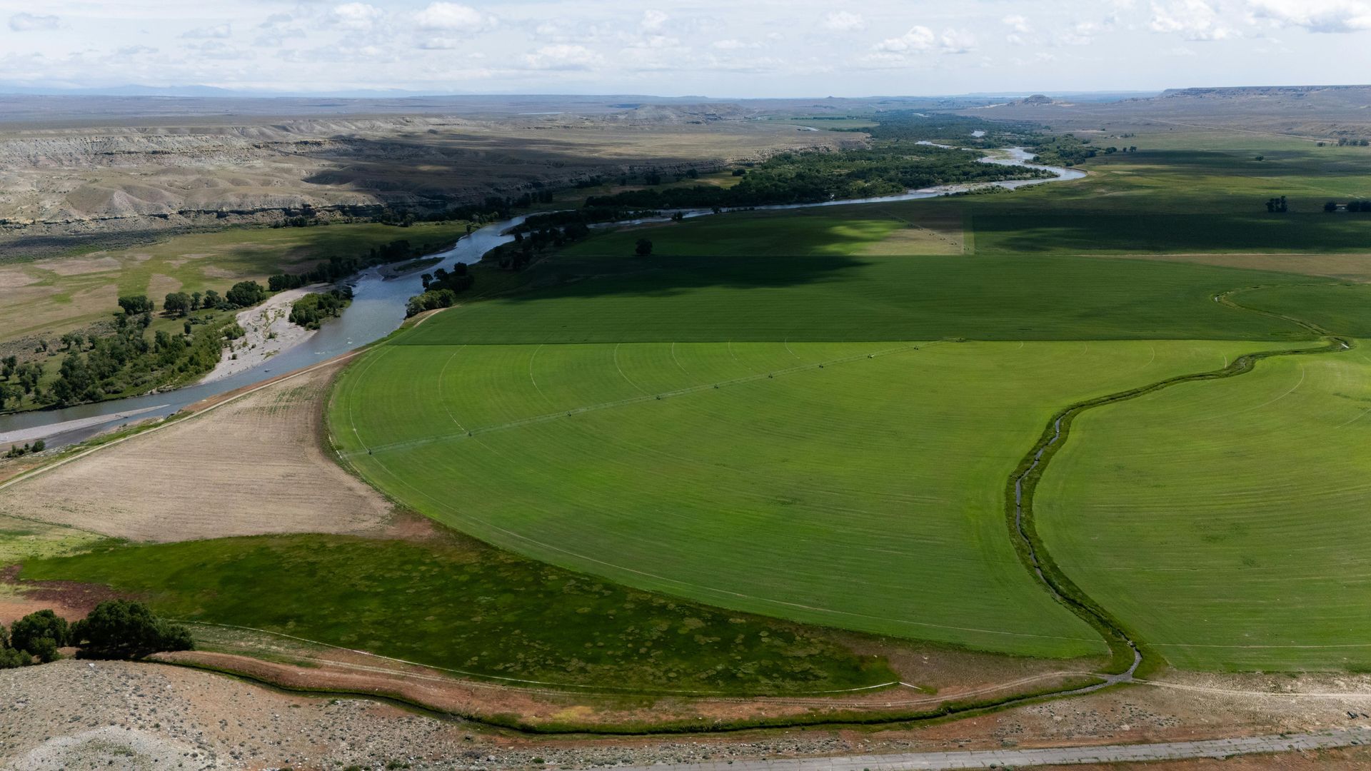
Drone aerial surveys use unmanned aerial vehicles (UAVs) fitted with high-resolution cameras and advanced sensors to capture detailed images and data from above.
These surveys let you gather land details quickly, without danger, and for less money, even in vast or hard-to-reach places.
This modern approach to data collection contrasts with traditional methods, which often rely on total stations and ground crews.
Picture this: high above, these tools collect everything from the land's contours to existing structures and environmental health.
The details collected from the air enable engineers to select the best path forward for their work, from start to finish.
Businesses can now create precise maps and models, far more accurate than anything previously available.
Benefits of Drone Surveys for Civil Engineering in Frankfort
The advantages of using drone services for civil engineering are substantial, particularly for small businesses or established service companies seeking to enhance efficiency.
Expect real precision.
Drones snap clear pictures from above and take exact measurements.
We match these up with fixed points on the ground to get super accurate survey data.
Frankfort's engineers rely on these detailed specifics to build truly precise site plans and realistic 3D models.
Consider this: you'll stop making costly mistakes.
And you get to skip those repetitive, time-consuming surveys that used to eat up your day.
Time and Cost Savings
Traditional surveying services can take days or even weeks, depending on the size and complexity of the terrain.
Drones can survey a vast land area in just a few hours.
This quicker pace cuts serious expenses for Frankfort's construction and engineering work.
Enhanced Safety

Many construction sites or existing structures pose safety risks for on-foot inspection services.
Drones permit engineers to collect necessary data from a safe distance without putting personnel in harm's way.
When you build in Frankfort, especially a large structure, on challenging ground, or near a busy road, you need to be extremely careful.
Applications of Drone Aerial Surveys in Frankfort's Civil Engineering Projects
The uses for aerial surveying are diverse and impactful.
Drones collect valuable info right from the start.
That data helps teams make sharper choices, even during the final safety checks.
Infrastructure utility
We can now inspect our bridges, roads, and other critical public structures much faster and more safely.
Drones help groups like the Kentucky Transportation Cabinet ensure everything remains in good working order.
You might miss severe damage—things like deep cracks, concrete chipping off, or soil washing away—if you only look from the ground.
Thinking ahead allows cities and road crews to maintain their bridges and roads much better.
Construction Progress Monitoring
With regular drone surveys, Frankfort's project managers can effectively monitor construction progress.
From high above, you can easily check the progress on site against the original plans.
This means spotting any mismatches quickly, before they become bigger headaches.
Regular check-ins ensure that building projects stay on track and don't exceed budget.
Land Management
Imagine getting super-accurate maps of Frankfort's diverse landscape; drones make that happen easily.
To properly build new sites, roads, or drainage, these maps are incredibly valuable.
They allow engineers to see the terrain clearly, enabling them to design structures that work in harmony with the natural landscape, rather than against it.
We use these aerial maps to check the land's environment before any building starts.
Clear maps are also essential for resolving land ownership questions and showing the exact boundaries of your property.
While not a replacement for a formal boundary survey conducted by a licensed surveyor, drone data can provide an excellent preliminary overview.
Obtaining accurate information from these surveys significantly enhances our development services.
Challenges and Considerations
While drone technology offers numerous benefits, engineering firms in Frankfort also face challenges that must be managed.
To make this happen well, you must know them.
Proper planning can mitigate most of these issues.
Weather Conditions
Frankfort's weather can be a significant factor.
Gusty winds, pouring rain, and very hot or cold air make it hard for drones to fly steadily and collect good information.
Engineers and pilots must schedule surveys during favorable weather windows to avoid project delays.
Regulatory Compliance
Drone operators in Frankfort must adhere strictly to all FAA regulations and local ordinances.
This includes having an FAA-certified pilot, respecting no-fly zones, and maintaining a visual line of sight with the drone during operations.
Navigating these rules varies from state to state, with Kentucky's requirements differing from those in nearby West Virginia or as far as South Carolina.
Data Management

Drone aerial surveys generate a very large amount of data.
A single flight can produce gigabytes of images and sensor readings.
Civil engineering firms in Frankfort need powerful computing systems and robust data storage solutions to process and manage this information effectively.
The Future of Drone Aerial Surveys in Frankfort's Civil Engineering
As drone technology continues to improve, its applications in Frankfort's civil engineering projects will only expand.
Get ready for drones that fly for hours, see with incredible clarity, and process information instantly.
Expect aerial surveys to deliver much greater worth.
Drones will soon integrate more effectively with other technologies.
Think of artificial intelligence and Building Information Modeling working in tandem.
Imagine these combined systems.
They'll automatically watch Frankfort's public works and even predict when repairs are needed.
Our city's structures will become much tougher and smarter.
Choosing a Drone Survey Provider in Frankfort
If you are planning to use drone aerial surveys for a civil engineering project in Frankfort, selecting the right provider is crucial.
Find service companies that actively demonstrate their expertise in civil engineering.
It's vital they also know all the local and federal laws inside and out.
A company's professional services should align with your project goals.
When evaluating different providers, ask direct questions about their skills and what they can actually deliver.
So, which drones are they flying, and what specific gear do those machines carry?
Could they share contacts from other similar construction jobs?
From their responses, you'll see if they're the right fit to bring your project the solid data it needs.
Key questions to ask potential drone service providers include:
- Are all your pilots FAA-certified and insured for commercial operations?
- What kind of major construction projects have you managed?
- What do your standard mapping services include as a final deliverable?
- How do you verify that the information you gather from above is reliable?
- Do you also conduct traditional boundary surveys, or is your main work aerial mapping?
Conclusion
Drone aerial surveys are fundamentally changing civil engineering in Frankfort, Kentucky.
Gathering important details for large construction jobs has just become easier.
This approach collects what's needed with great speed, safety, and exactness.
This technology also keeps getting better.
Soon, it will completely change how we plan, build, and keep up Frankfort's structures.
Ready to view your project from new heights?
Contact 1st Choice Aerials today to schedule your aerial photography, inspection, or thermal imaging service!


