Using Drones for Construction Progress Monitoring and Reporting
Key Takeaways:
- Drone progress monitoring captures comprehensive site conditions 60-70% faster than traditional ground-based documentation methods while providing superior visual perspective
- Regular aerial surveys enable project managers to identify schedule delays, budget overruns, and coordination issues before they escalate into costly problems
- Consistent flight paths and georeferenced imagery allow precise comparison between current site conditions and project plans, highlighting discrepancies immediately
- Stakeholder reporting improves dramatically when project teams can share clear aerial imagery and 3D models instead of relying solely on written status updates
- Automated progress tracking through drone surveys creates permanent documentation that protects against disputes and supports accurate as-built records
Construction project management has always involved a fundamental tension between maintaining detailed oversight and keeping projects moving forward. You need to know what is happening on site, but walking every corner of a large project takes time that delays decision-making. Traditional progress documentation methods provide snapshots, but they miss the comprehensive view needed to spot emerging issues before they become expensive problems.
At 1st Choice Aerials, we work with construction teams throughout Ohio who have transformed how they monitor and report project progress through professional drone services. The difference between checking boxes on a checklist and actually understanding site conditions becomes clear when you see the same project from both perspectives. Let us share what we have learned about using aerial technology to keep construction projects on track and stakeholders properly informed.
Why Traditional Progress Monitoring Falls Short
Every construction manager knows the routine. Walk the site with a clipboard or tablet, take some ground-level photos, make notes about what got completed, identify issues that need attention, and compile everything into a progress report. This process works in the sense that it produces documentation, but it has significant limitations.
Ground-level observation provides a limited perspective. You see what is directly in front of you but miss the bigger picture of how different work areas relate to each other. Large sites require hours of walking to cover adequately, and even then, some areas remain difficult to access or observe properly. Elevated work, roof conditions, and site perimeters often get documented inadequately simply because getting a clear view requires special equipment or risky positioning.
The time investment creates a dilemma. Thorough site inspections take project managers away from other responsibilities. Rushed inspections save time but miss important details. Either way, the documentation gets created after the fact, when issues have already developed rather than when early intervention could prevent problems.
Photography from ground level captures specific features but struggles to show spatial relationships, overall site organization, or the true state of progress across the entire project. A photo of a completed foundation wall does not show whether the wall is in the correct location relative to other site features. Images of installed structural steel do not reveal whether the erection sequence is proceeding efficiently or creating congestion.
How Drone Progress Monitoring Works
Aerial progress monitoring operates differently from ground-based methods because it captures comprehensive site data rather than selective observations. The construction services we provide at 1st Choice Aerials start with understanding what information project teams actually need, then designing flight missions that capture that data efficiently.
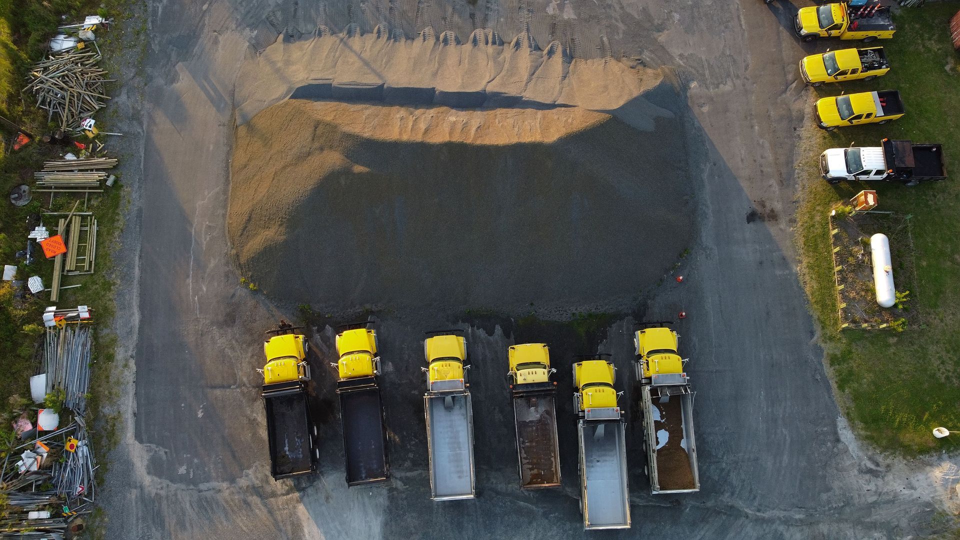
A typical progress monitoring flight follows a predetermined path over the construction site, capturing high-resolution imagery from consistent altitudes and angles. This systematic approach ensures complete coverage of the site during each flight. When we fly the same mission weekly or monthly throughout a project, the resulting imagery provides directly comparable views that make progress tracking straightforward.
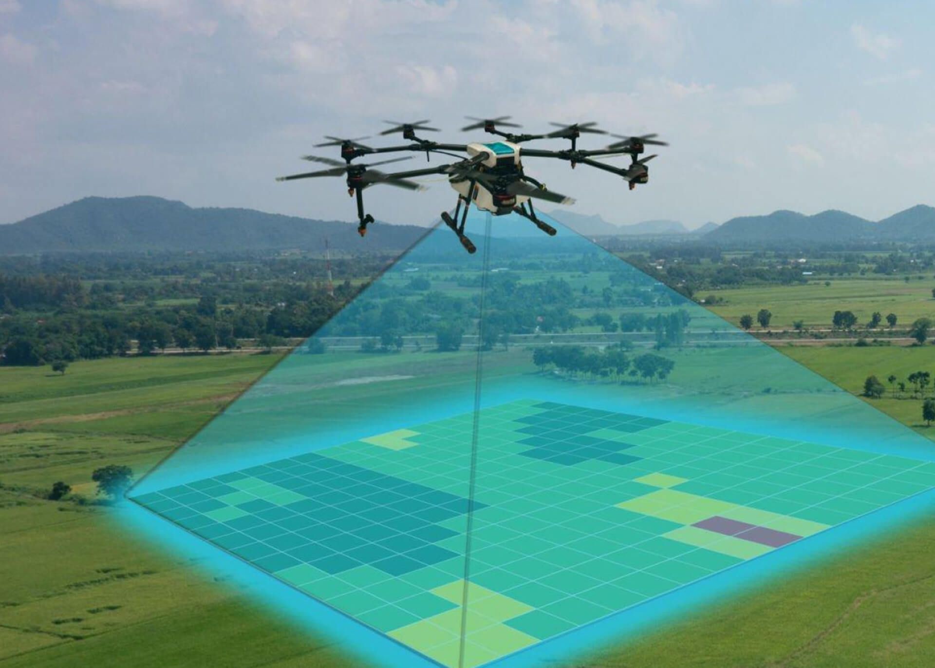
The drone captures hundreds or thousands of photographs during each flight, with substantial overlap between adjacent images. Photogrammetry software processes these overlapping images to create orthomosaic maps that show the entire site from directly overhead with uniform scale. Unlike traditional aerial photography where perspective distortion makes measurements unreliable, orthomosaic maps provide accurate measurements of distances, areas, and features.
Beyond flat maps, the same imagery generates 3D models of the construction site. These models help project teams visualize vertical progress, identify elevation discrepancies, and communicate complex spatial relationships to stakeholders who may not read construction drawings fluently. The ability to view the site from any angle, measure heights and slopes, and overlay design models creates powerful analysis capabilities.
Georeferencing ties every pixel in the aerial imagery to precise GPS coordinates. This spatial referencing allows direct comparison between aerial data and project plans, highlighting where constructed conditions match design intent and where discrepancies exist. It also enables accurate measurement of completed quantities for payment applications and progress tracking.
Benefits for Project Management and Coordination
Construction projects involve coordinating multiple subcontractors, tracking countless tasks, and maintaining schedules that depend on proper sequencing of work. Aerial progress monitoring improves management effectiveness in several specific ways.
Early issue detection represents perhaps the most valuable benefit. When you can see the entire site clearly and compare current conditions against plans and previous surveys, problems become visible earlier. A foundation poured in the wrong location, grading that does not match design elevations, or materials staged where they will interfere with upcoming work all become apparent in aerial imagery before they cause downstream delays.
According to research from the MDPI Drones journal, aerial monitoring enables project managers to assess construction progress and identify potential issues that would otherwise go unnoticed during standard ground inspections. This early visibility translates directly into cost savings when corrections happen before additional work proceeds based on incorrect conditions.
Coordination between trades improves when everyone works from the same visual information. Aerial imagery shows where each trade has been working, what they have completed, and where conflicts might emerge. Rather than relying on each subcontractor's word about their progress, project managers see objective documentation of site conditions.
Schedule tracking becomes more accurate and less subjective. Instead of asking superintendents to estimate percent complete on various tasks, project teams can measure actual quantities of work in place and compare against planned quantities. Concrete placement, structural steel erection, roofing installation, and similar measurable activities become quantifiable through aerial data.
Safety oversight benefits from the comprehensive view that aerial monitoring provides. Site organization, traffic patterns, material storage, and environmental compliance all become visible in ways that ground-level observation might miss. Potential hazards like unsecured materials, inadequate erosion control, or dangerous access points show up clearly in aerial imagery.
Stakeholder Communication and Reporting
Construction projects serve multiple stakeholders with different information needs and varying levels of technical knowledge. Owners want to see their investment taking shape. Lenders need verification that work has been completed before releasing funds. Architects and engineers require confirmation that construction follows design intent. Public agencies often mandate progress documentation for permits and approvals.
Traditional progress reports rely heavily on written descriptions, tables of completed tasks, and selective photography. These reports communicate facts but often fail to convey the actual state and feel of the project. Stakeholders without construction backgrounds struggle to understand what the numbers and descriptions actually mean on the ground.
Aerial imagery transforms stakeholder communication by providing clear visual evidence that anyone can understand. A bird's eye view of the construction site shows progress in intuitive ways that need little explanation. Seeing foundation walls laid out, structural frames rising, and building envelopes closing in tells a story that resonates with all stakeholders regardless of technical expertise.
Video content created from aerial footage adds another dimension to reporting. Time-lapse sequences compiled from regular flights show months of progress compressed into minutes, making the pace of work visible and tangible. These visual narratives work effectively in presentations to ownership groups, marketing materials for pre-leasing efforts, and public relations when projects have community interest.
The consistency of aerial documentation improves communication reliability. When stakeholders receive regular updates using the same perspective and format, they develop familiarity with the site and can easily identify changes between reporting periods. This consistency builds confidence and reduces the need for extensive explanation of what has changed.
At 1st Choice Aerials, we process aerial data into formats that work smoothly in common reporting workflows. High-resolution images suitable for presentations, orthomosaic maps with measurement tools, 3D models for interactive exploration, and annotated documentation highlighting key features all support effective stakeholder communication.
Frequency and Timing of Progress Flights
Determining how often to conduct aerial progress surveys depends on project characteristics, phase of construction, and stakeholder requirements. Different situations call for different monitoring frequencies.
Weekly flights suit fast-moving projects where conditions change rapidly and close oversight provides value. Large earthwork projects, structural steel erection, and projects with aggressive schedules benefit from frequent monitoring that catches issues while they remain easy to correct. The incremental cost of additional flights often pays for itself through early problem detection.
Monthly monitoring works well for projects with moderate pace and standard oversight requirements. This frequency provides regular documentation without excessive cost, and monthly intervals align with common billing cycles and progress meeting schedules. Most construction projects we work with find monthly aerial surveys provide the right balance of information and investment.
Milestone-based flights capture site conditions at critical project stages regardless of calendar schedule. Foundation completion before backfill, structural frame completion before envelope work, and substantial completion before final inspections all represent logical times for comprehensive documentation. These milestone surveys create permanent records of conditions that become hidden as construction proceeds.
Event-driven surveys respond to specific situations rather than following predetermined schedules. Unusual weather events, accidents, disputes over completed work, or changes in project scope all create situations where immediate aerial documentation provides value. Having the capability to deploy quickly when needs arise protects projects against uncertainty.
The timing of flights within project schedules matters as much as frequency. Flying after key work has been completed but before it gets covered allows verification without disrupting work. Coordination with project schedules ensures aerial surveys capture relevant information without creating delays or requiring special mobilization.
Creating Permanent Project Records
Construction generates enormous amounts of temporary information. Daily reports, inspection records, delivery tickets, and progress photos document activities but often lack organization that makes information retrievable later. When disputes arise, warranty claims emerge, or facility managers need information years after completion, finding relevant documentation becomes difficult.
Aerial surveys create organized, georeferenced records that remain valuable throughout a project's lifecycle and beyond. Each flight generates a permanent snapshot of site conditions at a specific date, providing irrefutable documentation of what existed when.
This documentation protects against claims and disputes. When subcontractors claim they completed work that project records do not show, aerial imagery provides objective evidence. When owners question whether site conditions matched approved plans, georeferenced surveys show exactly what was built where. The impartial nature of aerial data makes it credible for resolving disagreements.
As-built documentation benefits from aerial records compiled throughout construction. Rather than relying solely on marked-up drawings and field notes, project teams can reference actual imagery showing how elements were installed. This visual record helps future renovation projects, facility management activities, and warranty work by showing conditions that became concealed during construction.
Our mapping services create comprehensive site documentation that integrates with project archives and facility management systems. The structured nature of aerial data makes it searchable and accessible years after project completion, maintaining value long after traditional paper records would be lost or degraded.
Integration with Construction Technology
Modern construction projects utilize various technology platforms for scheduling, cost tracking, document management, and coordination. Aerial progress monitoring becomes more valuable when it integrates with these existing systems rather than creating isolated data silos.
Building Information Modeling workflows incorporate aerial data for progress verification and clash detection. By comparing 3D models generated from aerial surveys against design models, project teams identify where constructed conditions deviate from plans. This comparison happens visually and spatially rather than through tedious manual checking of dimensions.
Project management software platforms increasingly support integration with aerial data sources. Progress tracking dashboards can display current site imagery alongside schedule information, providing visual confirmation of milestone completion. Cost tracking systems can link payment applications to aerial documentation showing completed work.
According to the Construction Industry Institute, integration of visual progress data with project management systems improves decision-making effectiveness by providing comprehensive information in consistent formats. This integration reduces the time project managers spend gathering information and increases the time available for analysis and action.
Cloud-based platforms for aerial data processing and sharing enable collaboration across distributed project teams. Owners, architects, engineers, and contractors can access current site conditions from anywhere, facilitating informed discussions without requiring everyone to visit the site. This accessibility proves particularly valuable for projects with remote stakeholders or when travel restrictions limit site access.
Practical Considerations for Implementation
Successful aerial progress monitoring programs require planning and coordination beyond simply flying drones over construction sites. Several practical factors influence how well aerial surveys serve project needs.
Flight planning should consider site characteristics, surrounding airspace, and information requirements. Large projects may need multiple flights to capture adequate detail across the entire site. Sites near airports or in controlled airspace require proper authorizations before flying. Understanding what information the project team actually needs helps design flights that capture relevant data efficiently.
Weather affects when flights can occur and the quality of resulting imagery. High winds ground drones regardless of pilot skill. Heavy overcast creates flat lighting that makes terrain features less visible. Planning flexible schedules that accommodate weather delays ensures progress monitoring continues despite environmental challenges.
Site access and coordination with construction activities prevents conflicts and safety issues. We coordinate with site superintendents before each flight to ensure work areas are safe for aerial operations and that our presence does not interfere with critical activities. Active crane operations, concrete pours, and other sensitive work sometimes require rescheduling flights to avoid disruption.
Data processing capabilities determine how quickly aerial information becomes available for decision-making. Raw imagery has limited value until processed into orthomosaic maps, 3D models, and deliverable formats. Our processing workflows at 1st Choice Aerials prioritize turnaround time so project teams receive information while it remains current and actionable.
The 1st Choice Aerials Approach to Progress Monitoring
We bring more than drone technology to construction progress monitoring. Our team includes professionals with backgrounds in construction, engineering, and project management. This experience means we understand what project teams need to see and how to capture data that answers their actual questions rather than just producing pretty pictures.
When we work with construction teams on progress monitoring programs, we start by understanding project specifics. What are the critical path activities? What areas of the site deserve extra attention? What information do stakeholders need to see? These questions shape flight plans and deliverable formats to match project requirements.
Throughout Ohio and surrounding regions, we provide construction progress monitoring services that adapt to project needs. Whether you manage a single large project or oversee multiple sites, whether you need weekly flights or milestone documentation, we configure our aerial services to support your specific situation.
The consistency of working with the same drone service provider throughout a project creates continuity in documentation. Pilots familiar with your site notice changes more readily. Processing workflows tuned to your preferences deliver information in formats you can use immediately. This consistency compounds value as projects progress.
Taking Construction Oversight to the Next Level
Construction progress monitoring represents more than just documentation. It provides the comprehensive visibility that enables proactive management, informed decision-making, and effective communication. When you can see your entire project clearly and track how conditions change over time, you manage with confidence rather than reacting to surprises.
Aerial technology has matured to the point where progress monitoring no longer involves experimental approaches or unproven methods. The tools work reliably, the data proves accurate, and the benefits justify the investment. Construction teams throughout Ohio and beyond now consider aerial progress monitoring a standard practice rather than a luxury.
If your construction projects would benefit from better visibility, more complete documentation, and improved stakeholder communication, we invite you to explore how professional drone services can support your project management goals. Contact 1st Choice Aerials today to discuss your progress monitoring needs and learn how we help construction teams track projects more effectively through expert aerial data collection and analysis.