
Elevate Your Columbus Project with Our Aerial Drone Service
Drones are a common sight, buzzing in the sky above Columbus.
Local businesses can use an aerial drone service to improve operations - it's far more than a fun hobby.
Imagine seeing the world from a bird's-eye view!
These aircraft provide that, and so much more.
They're incredibly useful tools for many purposes.
For Ohio businesses, professional drone services might be just what the doctor ordered.
This guide will help you decide.
Ready to view your construction project from new heights?
Contact 1st Choice Aerials today to schedule your aerial photography, inspection, or thermal imaging service!
On This Page:
Understanding Aerial Drone Technology
Drones, formally known as Unmanned Aerial Vehicles (UAVs) or unmanned aerial systems (UASs), are sophisticated aircraft that operate without a human pilot on board.
They are controlled remotely by a certified drone pilot or fly autonomously via pre-programmed flight paths using onboard computers.
Originally used by the military, this technology is now a big player in many commercial industries.
These flying robots are highly customizable.
You can attach many different kinds of cargo.
Think cameras, sensors, or even small packages.
High-resolution cameras for detailed visual data capture are standard, alongside thermal sensors for detecting temperature variations andLiDAR (Light Detection and Ranging)for precise distance measurements and 3D mapping.
The data from these advanced sensors is spot on.
It gives us amazing insights from the air.
Why Your Columbus Business Might Need an Aerial Drone Service
You might question whether these aerial drone services are suitable for your specific business needs.
Numerous compelling reasons exist to consider integrating drone technology.
Lots of Ohio industries can benefit from aerial drones.
Progressive companies are finding that drone services pay off.
One advantage is significant cost reduction.
Traditional methods for tasks like comprehensive site surveys or inspections often involve expensive equipment rentals, including helicopters or scaffolding.
Drones frequently accomplish these tasks for a fraction of the cost and offer impressively fast turnaround times.
Drone projects?
These are quicker, cutting down on both time and worker costs.
Accessing Tough Spots with Ease
Numerous job sites feature locations that are challenging or dangerous for human access, such as very steep roofs, confined spaces, or densely packed industrial zones.
Drones, with their compact size and maneuverability, can navigate these areas effortlessly.
You get a perfect, unhindered view.
Consider the task of inspecting a tall bridge structure within Franklin County.
Deploying a human inspection team could involve days of preparation, significant safety risks, and considerable expense.
An aerial drone, operated by a skilled drone pilot, can capture detailed visuals and critical data much more rapidly and safely, simplifying otherwise complex tasks.
Common Uses for an Aerial Drone Service in Columbus
What specific tasks can an aerial drone service accomplish for your Columbus business?
The uses are widespread and growing all the time.
The applications of drone technology are expanding rapidly within local industries.
Think precision agriculture, infrastructure inspection, and search and rescue operations.
Drone companies offer a bunch of different services.
Prepare to be Amazed
High-flying drones capture stunning images and videos from angles you just can't get otherwise.
Marketing many different kinds of projects and businesses is easier with this tool.
It's great for commercial properties.
Great photos from a drone can really make your ads and website look amazing.
Businesses love using them to get noticed.
In Columbus, real estate agents frequently use aerial drone services to obtain compelling drone photos and drone imagery of properties, showcasing homes and commercial real estate from captivating angles.
This is often referred to as real estate drone photography or estate photography.
Use a drone to shoot amazing HD video and photos for your property listings.
Potential buyers will love the virtual tours, and you'll sell houses quicker.
Showing off a commercial property's best features?
Aerial views are a must.
They highlight location, size, and amenities.
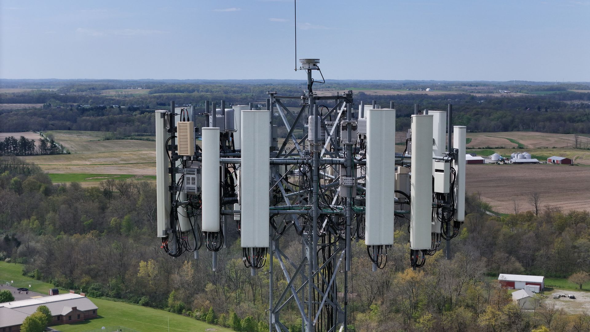
Detailed Site Inspections
Detailed site inspections represent a significant application for aerial drone services.
Inspecting roofs, chimneys, building facades, bridges, power lines, and cell towers is safer and easier with drones.
Inspecting hard-to-reach or dangerous areas is now easier than ever.
Mechanics, engineers, and maintenance personnel can assess conditions without physically being present.
Think of it like this: a drone's sensors act like a super-powered magnifying glass.
They can see minuscule damage, flaws, or potential failure points, which would be totally invisible to the naked eye from a ground-level perspective.
This early identification of issues through regular drone inspection can prevent minor problems from escalating into costly, extensive repairs.
Aerial data provides a big picture view, helping us plan maintenance more effectively.
Accurate Mapping and Land Surveying
Accurate mapping and land surveying are additional strengths of an aerial drone service.
Rapid drone surveys provide extensive geographic data.
We process this data to make super-accurate maps, elevation models, 3D point clouds, and detailed land surveys.
Architects, civil engineers, construction planners, and land developers in Columbus?
These mapping products are a game-changer for them.
With access to fresh aerial photos and detailed site maps, project planning just got a whole lot easier for professionals.
They can confidently create more accurate plans.
Existing site conditions, including terrain contours and current structures, are captured with exceptional detail through quality aerial surveys.
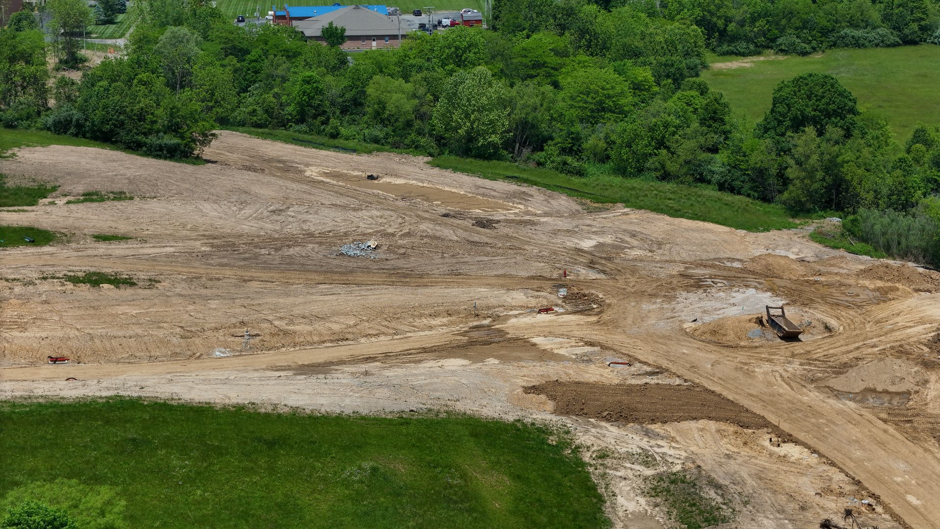
Keeping an Eye on Construction Projects
Monitoring construction sites is an ideal application for drones.
Regular flights over a job site provide consistent construction progress updates for all stakeholders.
Tracking timelines and resources becomes simple for project managers.
They get a visual snapshot of how work is going.
Clients see their investment grow with clear visual reports.
These reports use drone footage to show them exactly what's happening.
Looking down from above, you can easily catch potential problems early on, saving you time and trouble.
Active monitoring means we catch issues early.
This helps us stay on schedule and under budget - it's a win-win!
Helping Columbus Agriculture
Although Columbus is primarily an urban center, the surrounding regions encompass significant agricultural land.
Farming is changing thanks to drones.
They give farmers a big boost.
Large fields are easily monitored for crop health, providing data otherwise difficult to collect on foot.
Equipped with specialized sensors, such as multispectral cameras, agricultural drones can capture data beyond the visible spectrum.
Calculating vegetation indices—like NDVI—helps pinpoint plant stress, growth differences, and areas needing attention, such as targeted irrigation or fertilizer.
Farmers can use resources better with precision agriculture.
This method improves how they farm.
Finding the Best Aerial Drone Service in Columbus
Once you decide to explore what drones can achieve for your business, selecting the right aerial drone service in Columbus is the next step.
The best choice hinges on a few things: cost, quality, and your needs.
You need a provider who is not only skilled and reliable but also a good fit for your specific project requirements and part of the growing drone industry.
Begin by evaluating their experience.
Ask to see a portfolio of their past drone work and look for relevant case studies.
Their skills and the quality of their work really shine through in a good portfolio.
Especially if it includes projects that match your needs.
Aerial Drone Service Selection Quick-Reference Table
| Factor to Check | Why It's Important | Traditional Aircraft (Planes/Helicopters) |
|---|---|---|
| FAA Part 107 Certification | Permits legal and safe operations. | Higher acquisition/rental & operational costs. |
| Experience & Portfolio | Shows their skill and past success. | Higher altitudes are possible, longer range & flight times. |
| Insurance Coverage | Protects your business from liability. | Less maneuverable at low altitudes (planes), helicopters offer hover. |
| Quality of Equipment | Affects data accuracy and image quality. | Requires licensed pilot, follows standard aviation regulations. |
| Local Knowledge | Helps with the Columbus airspace and conditions. | Large area surveys, high-altitude shots, film production, long-duration monitoring. |
| Communication Skills | Means your project needs are understood. | Lower operational costs, faster completion |
Reading online reviews or asking for references can also help. Do a little research - you'll be glad you did.
You want to partner with a trustworthy team. Your drone project will succeed because of this.
What Does an Aerial Drone Service Cost in Columbus?
Cost is an important factor in any business decision, and the price of an aerial drone service in Columbus can vary based on several elements.
There isn't a standard, one-size-fits-all pricing structure for drone work.
The project's size and what it needs to include directly affect the final price.
The complexity of the job is a primary factor.
For instance, a straightforward aerial photo shoot for real estate marketing will typically cost less than a detailed topographical survey requiring 3D modeling and extensive data analysis.
What kind of drone and sensors are used?
That's a big factor in the price.
For example, using top-of-the-line LiDAR or thermal imaging cameras makes the service more expensive because the equipment costs a lot.
Columbus Area - Poised for a Drone Revolution
Get ready for amazing advancements in drone technology!
Aerial drone services will have even more to offer in the years ahead.
Drone technology is advancing rapidly.
We're seeing longer flight times, heavier payloads, and drones built for very specific jobs.
Sensors are getting smaller, more potent, and better at collecting really detailed aerial information.
It's all happening at once.
Drones are getting smarter.
Artificial intelligence is the reason why.
AI algorithms can analyze vast amounts of drone-collected data much faster and more accurately than manual methods, automatically identifying patterns, anomalies, or objects of interest.
Drones are improved by automation.
This helps with things like checking infrastructure, monitoring agriculture, and watching over construction sites.
Efficiency is increased, making the whole process better.
Working With Your Columbus Aerial Drone Service Partner

After selecting your Columbus aerial drone service provider, establishing a collaborative working relationship is the next phase.
Projects succeed when people communicate well.
It begins with a detailed project kickoff meeting or consultation to ensure everyone is aligned.
During this initial discussion, clearly articulate your goals and objectives.
What concrete benefits do we anticipate from the aerial drone service?
Will it improve efficiency?
Reduce costs?
Increase safety?
Let's define success!
What precise information, drone photos, aerial imagery, or types of drone videos do you require?
Provide comprehensive details about the project site, subject, or area of interest, as the more information the drone team possesses, the more effectively they can plan and execute the mission.
Conclusion
Lots of Columbus businesses, groups, and even hobbyists may find an aerial drone service really helpful.
From construction sites to farms, the advantages are obvious.
Businesses of all kinds, including real estate and infrastructure, are seeing real benefits.
Precision agriculture is even getting in on the action!
Safety goes up, costs go down, and the quality of aerial data improves dramatically when you use drones.
Ready to view your project from new heights?
Contact 1st Choice Aerials today to schedule your aerial photography, inspection, or thermal imaging service!


