
Aerial Photography in Ohio: The Buckeye State from Above
Have you ever looked down from a plane and just marveled at the view?
Seeing Ohio from above gives you a whole new perspective.
It turns familiar places into intricate patterns and reveals hidden beauty, making aerial photography in Ohio a fascinating field.
Getting those amazing shots takes skill and the right tools.
This applies whether you're flying a drone or taking pictures from a traditional aircraft.
For many aviation folks, exploring aerial photography in Ohio feels like a natural extension of their passion for flight.
It blends the technical side of aviation with the creative side of capturing images.
Let's explore what aerial photography work in Ohio involves.
Get ready to see the familiar landscapes of the state transformed!
Ready to view your construction project from new heights?
Contact 1st Choice Aerials today to schedule your aerial photography, inspection, or thermal imaging service!
On This Page:
Why Ohio is a Great Place for Aerial Views
Ohio offers a surprisingly varied landscape, perfect for stunning aerial shots.
You've got bustling cityscapes in Columbus near Broad Street, Cleveland along Lake Erie, and Cincinnati on the Ohio River.
These urban environments look incredible at dawn or dusk from above, with city lights creating intricate webs.
Don't forget Lake Erie's extensive shoreline and the many inland lakes and rivers like the Scioto or the Great Miami.
Water always adds a dynamic element to aerial photos, reflecting the sky and adding texture.
The rolling hills and forests of southeastern Ohio, including areas like Hocking Hills, offer different textures, elevations, and challenges for photographers.
Ohio landmarks, from historical sites like the Wright Brothers memorials to natural wonders, take on new meaning when seen from the sky.
Aviation enthusiasts can appreciate capturing views tied directly to the history of flight itself.
This visual diversity makes aerial photography in Ohio genuinely appealing for both artistic and commercial purposes.
The Gear Behind the Shot: Cameras and Platforms
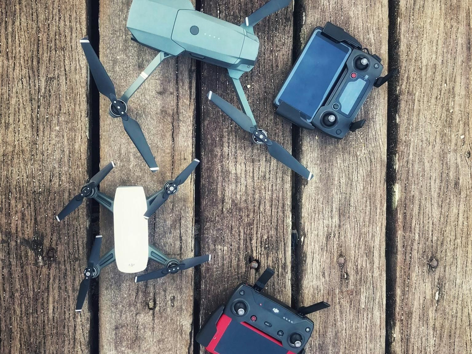
Getting great aerial photos depends heavily on the equipment.
You need both a stable flying platform and a capable camera system.
Let's look at the common choices for capturing those Ohio aerial views.
Drones Taking Flight
Drones, or Unmanned Aerial Vehicles (UAVs), have significantly impacted aerial photography.
They are relatively affordable, highly maneuverable, and much easier to deploy than traditional aircraft for many projects.
Companies like
DJI, Skydio, and Autel Robotics offer sophisticated yet user-friendly options suitable for professionals and hobbyists.
These drones often come equipped with built-in high-resolution cameras stabilized by advanced gimbals.
They use GPS and sensors for stable flight, even in moderate winds, which helps get sharp photos and smooth cinematic video.
Their smaller size lets them fly closer to subjects and potentially in tighter spaces, though strict regulations still apply, especially near people or infrastructure.
Traditional Aircraft Still Soar
Using fixed-wing airplanes like Cessna 172s or helicopters remains a vital part of professional aerial photography.
For licensed pilots, aircraft mechanics, and builders, this method feels familiar and offers distinct advantages.
It allows for much higher altitudes, covering vast areas quickly, and significantly longer flight times compared to most drones.
Helicopters offer the unique ability to hover and maneuver precisely, ideal for framing specific shots for commercial real estate or film production, but they come with higher operational costs.
Camera Setups
Regardless of the platform, the camera and lens combination are critical.
Many higher-end drones now carry cameras with sensors comparable to ground-based mirrorless or DSLR systems, such as Micro Four Thirds, APS-C, or even full-frame sensors on specialized models.
This allows for excellent image quality, dynamic range, and low-light performance.
Image stabilization, either in the camera body (IBIS), the lens (IS/VR/OSS), or both, is extremely beneficial to counteract the vibrations inherent in any aircraft.
Using fast shutter speeds (often 1/1000s or faster) is also typical to freeze motion and ensure sharp images despite the movement of the platform.
Using lens filters like Circular Polarizers (CPL) to reduce glare or Neutral Density (ND) filters for smoother video are also common practices.
A quick comparison of manned vs. unmanned aerial photograpy:
| Feature | Drones (UAVs) | Traditional Aircraft (Planes/Helicopters) |
|---|---|---|
| Cost | Lower initial & operational cost. | Higher acquisition/rental & operational costs. |
| Altitude/Range | Limited altitude (typically | Higher altitudes are possible, longer range & flight times. |
| Flexibility | Highly maneuverable, can operate in tighter spaces. | Less maneuverable at low altitudes (planes), helicopters offer hover. |
| Regulations | Part 107 (commercial) or Recreational rules require knowledge & often certification. | Requires licensed pilot, follows standard aviation regulations. |
| Best Use Cases | Real estate, close inspections, small area mapping, artistic low-level shots. | Large area surveys, high-altitude shots, film production, long-duration monitoring. |
| Cost | High labor costs, potential lift rental | Lower operational costs, faster completion |
Common Uses for Aerial Photography in Ohio
Aerial views aren't just visually appealing - they serve numerous practical functions across various industries in Ohio.
The application of drone photography and traditional aerial imaging is surprisingly broad.
You might encounter these stunning aerial perspectives more often than you realize.
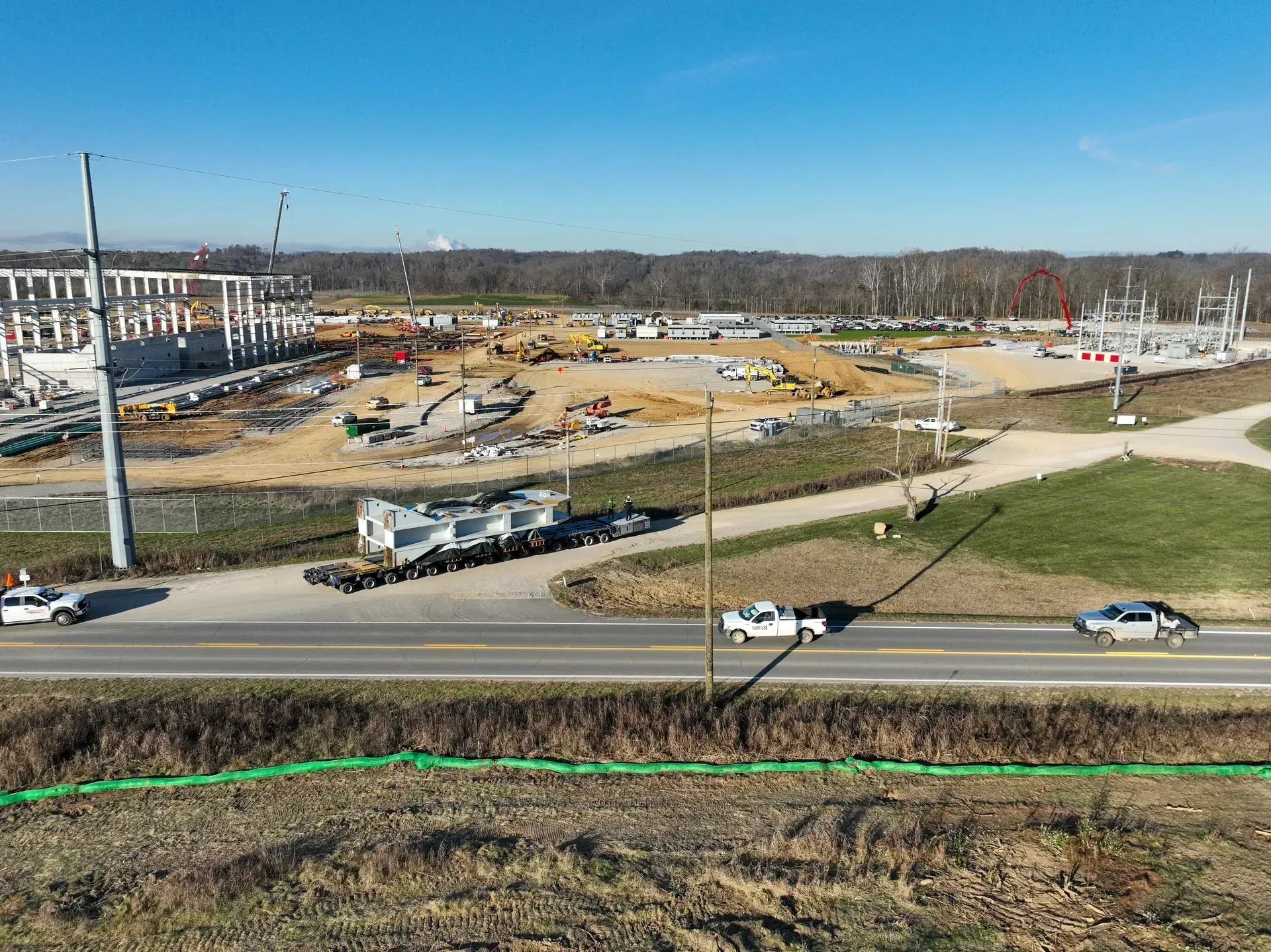
Real Estate and Development
Showing a property from above gives potential buyers a superior understanding of its layout, size, condition, and relationship to surroundings.
High-quality aerial images and video make listings stand out in a crowded market, especially for larger properties or commercial real estate.
Developers and builders use aerial photography extensively to track progress on construction sites, plan site layouts, document stages, and create compelling marketing materials for commercial real estate projects.
Agriculture and Environmental Monitoring
Ohio has a significant agricultural sector that benefits greatly from aerial technology.
Farmers use aerial imagery, often captured by drones equipped with multispectral sensors, to monitor crop health, identify stress areas, optimize irrigation, and guide precise application of fertilizers or pesticides.
This approach, sometimes called “precision agriculture”, helps increase yields and save resources.
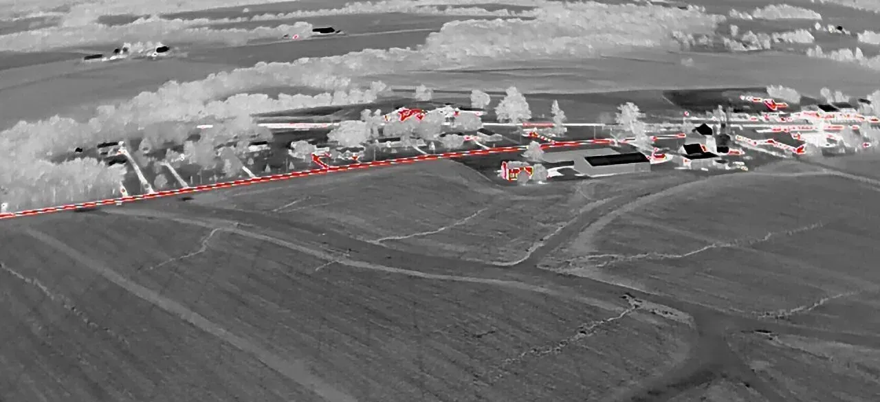
Infrastructure Inspection
Maintaining Ohio's vast infrastructure, including bridges, power lines, cell towers, wind turbines, pipelines, and railways, is a monumental task.
Aerial photography, particularly using drones, offers a safer, faster, and often more cost-effective method for inspecting these structures.
Skilled technicians can analyze high-resolution aerial images to spot potential defects, wear, or damage without needing risky manual climbs or expensive equipment like cranes.
Events and Marketing
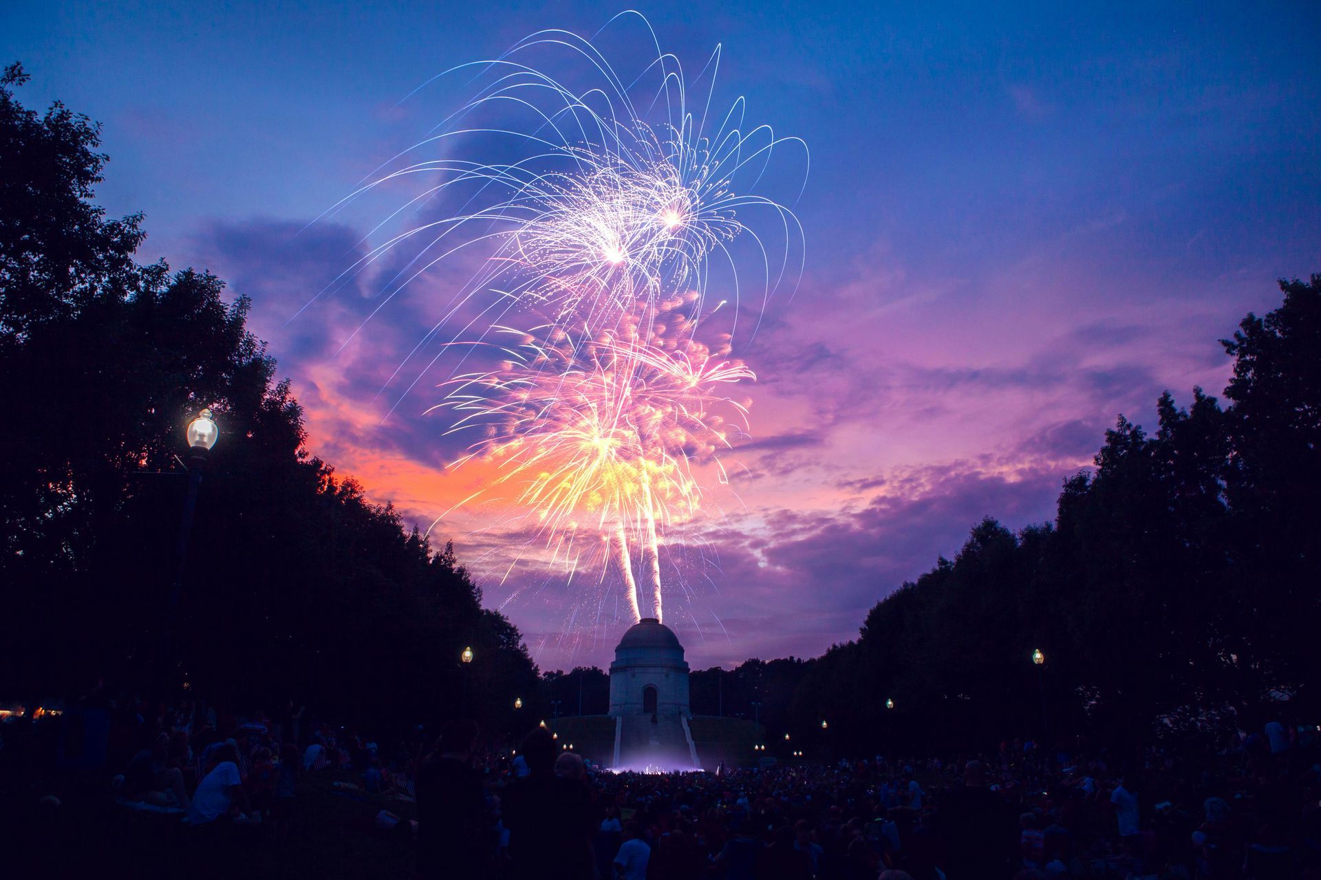
Large outdoor events such as festivals, concerts, fairs, or sporting events look spectacular from an aerial perspective.
Drone services provide shots that capture the scale, energy, and layout of the event, creating engaging promotional content.
Businesses across Ohio increasingly use aerial video and photos in their general marketing materials, websites, and social media to project a dynamic, modern, and professional image.
Surveying, Mapping, and GIS
Vertical aerial photography is fundamental to creating accurate maps and geographic information systems (GIS).
Specialized survey drones or cameras on traditional aircraft capture overlapping images that can be processed using photogrammetry software.
This creates detailed topographic maps, 3D models, and orthomosaic images used in urban planning, engineering, resource management, and land development.
Just for Fun and Art
Beyond commercial applications, many people engage in aerial photography simply for the creative enjoyment it offers.
Capturing beautiful Ohio landscapes, unique architectural perspectives, or abstract patterns from above is intrinsically rewarding.
Ohio's distinct four seasons provide endless artistic possibilities for enthusiasts seeking that perfect custom photo.
For aviation lovers, merging the experience of flight with the art of photography is a perfect combination.
It adds another layer of purpose and engagement to being airborne.
Sharing these unique Ohio aerial views through prints, online galleries, or social media can be very satisfying and inspire others.
Finding Professional Aerial Photography Services in Ohio
Perhaps you need professional aerial shots for your business or project, but don't have the equipment, license, or desire to capture them yourself.
Hiring a professional aerial photographer or drone service provider is an excellent option.
How do you find the right one for your needs?
First and foremost,
verify their credentials.
Look for a provider who is properly licensed and insured for commercial operations.
For drone work, this means they must hold a current FAA Part 107 Remote Pilot Certificate.
Make sure they carry liability insurance specifically covering aerial operations, not just general business insurance.
Tips for Aspiring Ohio Aerial Photographers
Are you interested in trying aerial photography in Ohio yourself?
With modern drone technology, it's a more accessible hobby or potential profession than ever before.
Here are a few tips to help you get started safely and effectively.
Start Simple and Safe
You don't need the most expensive top-tier drone or camera system right away.
Begin with a reliable, mid-range drone known for good flight stability, decent image quality, and safety features.
Focus on learning the basics of safe flying in open areas away from people and obstacles before attempting complex shots or challenging locations.
Practice Flight Control
Smooth and controlled flight is fundamental to capturing high-quality aerial photos and videos.
Practice basic maneuvers like hovering, ascending/descending, forward/backward flight, and rotating (yawing) smoothly.
Work on coordinating the drone's movements while simultaneously considering your camera angle and composition.
Learn how to frame shots effectively from an aerial perspective, which is very different from ground-level photography.
Experiment with various altitudes and camera angles (straight down, oblique, panning).
Remember that subjects, shadows, and textures look dramatically different from above.
Learn and Follow the Rules
This cannot be emphasized enough: know and meticulously follow all FAA regulations (see the
FAA.gov website) and any applicable state or local rules in Ohio.
Ignorance is not a valid excuse if you violate airspace rules or cause an incident.
Safety for people on the ground, manned aircraft, and property must always be your absolute top priority.
Use resources like the FAA's B4UFLY app or similar trusted applications before every single flight to check for airspace restrictions, Temporary Flight Restrictions (TFRs), and airport proximity warnings.
Understand the airspace classifications around Ohio airports and sensitive locations like military bases or critical infrastructure.
Responsible flying practices protect the privilege of flying for everyone and maintain the positive image of drone photography.
Understand Light and Weather
Light behaves differently when shooting from the air compared to the ground.
The "golden hours" – early morning shortly after sunrise and late afternoon before sunset – often provide the most dramatic, warm lighting with long shadows that accentuate textures.
Midday sun can be harsh from above, creating strong, unflattering shadows and potentially washing out details.
Consider the direction of the sun and how it illuminates your subject; backlighting or sidelighting can create compelling effects.
Weather conditions like cloud cover, fog, haze, and wind significantly impact aerial shots and flight safety.
Always check the weather forecast thoroughly before flying and be prepared to adapt your plans or postpone flights if conditions are unsuitable.
Master Post-Processing Basics
Most digital aerial photos benefit from some level of post-processing or editing.
Software like Adobe Lightroom, Adobe Photoshop, Capture One, or even capable mobile apps can help you adjust exposure, contrast, highlights, shadows, and color balance to make your images pop.
Cropping can also improve composition by removing distracting elements.
Learn basic editing techniques, but strive for natural-looking results rather than overly processed images unless a specific artistic style is intended.
Shooting in RAW format (if your drone/camera supports it) provides much more flexibility for adjustments in post-processing compared to JPEG.
Developing solid editing skills will significantly elevate the quality of your final aerial images.
Plan Your Flights
Good aerial photography often requires planning.
Scout locations beforehand (using online maps or even a ground visit) to identify potential shots, obstacles, and safe take-off/landing zones.
Create a pre-flight checklist covering equipment (batteries charged, memory cards formatted, propellers secure), regulations (airspace check, TFRs), and weather.
Think about the story you want to tell or the specific features you need to capture.
Consider factors like the time of day for optimal light, potential obstructions, and flight paths that minimize risk while maximizing visual impact.
A well-planned flight is usually a safer and more productive flight.
Conclusion
Aerial photography in Ohio truly offers a fantastic and diverse canvas for aerial photography.
From the intricate patterns of city lights in Columbus, Cincinnati, or Cleveland to the vast, rolling fields of its agricultural heartland, the view from above is consistently captivating.
Aerial perspectives provide insights and beauty that ground-level shots simply cannot replicate.
Ready to view your project from new heights?
Contact 1st Choice Aerials today to schedule your aerial photography, inspection, or thermal imaging service!


