How Drone Data Helps Track Construction Progress on Ohio Job Sites
Key Takeaways
- Drone progress monitoring gives construction teams a consistent, repeatable aerial record of job site activity from start to finish.
- Regular drone flights can identify delays, earthwork deviations, and compliance issues before they become expensive problems.
- Drone data supports stakeholder communication with clear visuals that replace slow, manual reporting.
- Volumetric measurements from aerial imagery help improve billing accuracy and material planning on Ohio job sites.
- Working with a direct provider, not a broker platform, means faster turnaround, clearer communication, and accountable data from flight to delivery.
There's a moment on almost every construction project where someone asks, "Where are we actually at?" Maybe it's a developer trying to update an investor. Maybe it's a project manager reconciling what's been billed versus what's been built. Maybe it's a GC trying to figure out why one phase is three weeks behind schedule.
Traditional progress monitoring methods don't answer that question cleanly. Site walks are time-consuming, photographs taken at ground level are inconsistent, and verbal updates leave too much room for interpretation. Drone data changes this entirely.
At 1st Choice Aerials, we work with commercial construction clients across Ohio to capture aerial data that gives teams a clear, accurate, and repeatable view of their job sites. Here's what that actually looks like in practice, and why it matters for construction projects across the state.
What Drone Data Actually Captures on a Job Site
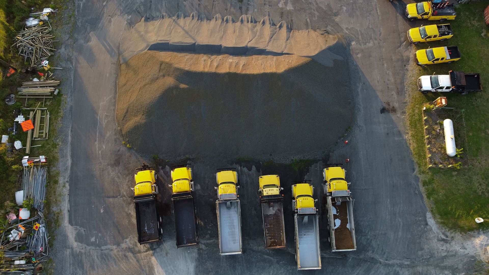
When we fly a construction site, we're not just taking pretty overhead photos. The data we collect typically includes high-resolution aerial imagery, orthomosaic maps, 3D point cloud models, and volumetric measurements, all georeferenced and timestamped.
What does that mean in plain terms? It means every image has a precise location attached to it. Every surface we capture can be measured. And every flight we run can be compared directly to the last one.
That kind of consistency is what makes construction drone progress monitoring genuinely useful. One set of aerial photos tells you something. A sequence of them, taken from the same altitude and flight path at regular intervals, tells you how a project is actually moving.
Tracking Progress Week Over Week
Here's where drone data earns its value on a real Ohio job site.
When we establish a consistent flight plan for a project, every subsequent flight produces comparable data. Contractors and project managers can pull up two sets of images side by side and see, visually and measurably, what changed between visits. Concrete poured. Grading completed. Materials staged and consumed. Structures rising.
This side-by-side comparison takes out the guesswork. Instead of relying on field reports or trying to reconcile notes from different subcontractors, teams have an objective aerial record of what actually happened on site and when. According to UAV Coach's construction drone guide, drones can survey up to 120 acres per hour compared to roughly five acres per hour using traditional ground-based methods. That kind of efficiency means more frequent monitoring without adding weeks of labor to the schedule.
For large commercial developments, infrastructure builds, or multi-phase projects across Ohio, that documentation matters. It supports schedule management, helps confirm completed work before payments are released, and gives everyone on the project the same picture of where things stand.
Earthwork, Grading, and Volumetric Measurements
Earthwork is one of the trickiest parts of any construction project to track accurately. Cut and fill estimates can shift quickly, stockpile volumes are hard to measure manually, and discrepancies between what was planned and what was moved tend to show up late, usually at billing time.
Drone mapping services give Ohio construction teams a way to monitor earthwork precisely. Using photogrammetry, we generate accurate 3D models of site terrain that can be measured and compared over time. Stockpile volumes can be calculated from aerial data with far greater consistency than manual methods, and cut-and-fill progress can be validated against the original grading plan.
This isn't just helpful for tracking. It supports cost control. When volumetric data is tied to quantities and cost codes, project managers can make better forecasting decisions and reduce the risk of surprises at the end of a phase.
Stakeholder Communication That Actually Works
Keeping investors, owners, and clients informed is a real challenge on active job sites. Not everyone can or should be walking the site weekly. And written progress reports, even detailed ones, rarely give a clear picture of what's happening on the ground.
Drone data changes how that communication works. We deliver structured deliverables, including annotated aerial imagery, time-lapse progress comparisons, and organized reports, that are easy to share and simple to understand. An owner in Columbus or a developer in Cincinnati doesn't need to be on-site to know what's happening on their project in Toledo or Dayton.
That kind of transparency tends to reduce the friction that comes with stakeholder management. When people can see the project with their own eyes, even from a distance, questions get answered faster and trust is easier to maintain.
Safety Inspections Without Putting Workers at Risk
Progress tracking isn't the only thing drone data supports. On active construction sites, our aerial inspection services let teams check structures, scaffolding, elevated work areas, and hard-to-reach locations without sending workers into dangerous positions.
That matters in Ohio, where commercial and industrial construction projects often involve complex, multi-story structures, towers, and infrastructure where manual inspection carries real safety risk. Drones can access areas that are difficult, slow, or hazardous to inspect by foot, and they do it without interfering with ongoing construction activities.
Our pilots are FAA Part 107 certified, which is the federal certification required for all commercial drone operations in the U.S. airspace. Every flight we run is conducted under those standards, and our team holds additional certifications in construction safety and thermography on top of baseline pilot credentials.
So when a general contractor needs a quick inspection of a roof structure or a subcontractor wants to verify scaffold placement, we can get that data without shutting anything down.
Catching Delays Before They Compound
One thing that makes consistent aerial monitoring valuable is how early it surfaces problems.
A single drone flight won't tell you much. But when you're flying a site every week or every two weeks and comparing the results to a project schedule, deviations start showing up quickly. Grading that's behind plan. A structural phase that hasn't progressed the way it should have. Materials that aren't where they're supposed to be.
Catching those things early matters because delays compound. A week of slippage in one phase pushes the next phase out, and then the next. By the time a problem shows up in a traditional progress report, it's often already grown into a cost issue or a schedule conflict with another trade.
Regular drone monitoring gives project teams a tool for catching those early signals and acting on them before the schedule absorbs the full impact.
Why Direct Service Matters for Construction Data
This is worth addressing directly, because it's something we hear about from clients who've worked with broker platforms before.
Several large platforms in the commercial drone space market aggressively, win the job, and then subcontract the actual work out, sometimes through two or three layers of intermediaries. That model creates inconsistency. Different pilots use different equipment. Data quality varies from flight to flight. And when something goes wrong or a deliverable doesn't meet expectations, accountability is hard to find.
At 1st Choice Aerials, we work directly with our clients. We don't operate through broker platforms and we don't pass jobs off to subcontractors. When you hire us for an Ohio construction project, the same team handles the flight planning, the data collection, the processing, and the delivery. That means consistent quality, faster turnaround, and a single point of contact from start to finish.
If you want to see the kind of work we deliver, take a look at our recent projects for commercial and industrial clients across Ohio.
What to Expect in Terms of Deliverables
Every project is a little different, but in most cases our construction progress monitoring deliverables include high-resolution aerial imagery from each flight, annotated progress comparisons, organized reports suitable for sharing with stakeholders and project managers, and optional 3D models or orthomosaic maps depending on the scope.
We deliver files within 24 to 48 hours of the flight, and we structure them to work with your existing reporting workflow. Whether you need Google Drive access, a shared folder, or a specific file format for your project management platform, we build delivery around what actually works for your team.
Ready to Track Your Ohio Job Site with Drone Data?
If you're managing an active construction project in Ohio and want consistent, accurate aerial data to keep it on schedule and your stakeholders informed, we'd like to talk.
Contact us here to request a quote or discuss your project scope. We serve job sites across Ohio, including Columbus, Dayton, Cincinnati, Cleveland, Toledo, and Akron, as well as expanding coverage in Kentucky and Indiana.
Frequently Asked Questions
How often should drone flights be scheduled for construction progress monitoring?
Most Ohio construction projects benefit from weekly or bi-weekly drone flights, though the right frequency depends on project pace and reporting needs. Faster-moving phases like site development or structural work often justify more frequent monitoring, while slower phases may call for monthly flights.
What deliverables does 1st Choice Aerials provide with progress monitoring?
Deliverables typically include high-resolution aerial imagery, time-lapse progress comparisons, annotated visuals, and structured reports for stakeholders. 3D models and orthomosaic maps can be added depending on the project scope and data requirements.
Can drone data be used to support billing and payment verification on construction projects?
Yes. Timestamped, georeferenced aerial data provides an objective record of completed work that can be referenced during draw requests, invoice reviews, and payment disputes. Volumetric measurements from drone imagery can also support earthwork billing and material tracking.
How accurate is drone mapping for construction applications?
When flown with enterprise-grade equipment and proper ground control, drone mapping can achieve centimeter-level accuracy. This makes it reliable for applications like cut-and-fill volume calculations, grading verification, and as-built comparisons with engineering plans.
Are commercial drone pilots required to be FAA certified?
Yes. Any drone operation conducted for commercial purposes in the United States must be carried out by a pilot holding an FAA Part 107 Remote Pilot Certificate. This certification covers regulations, airspace rules, weather assessment, and safe operating procedures.
Is drone progress monitoring disruptive to active job sites?
Generally speaking, no. FAA-certified drone pilots conduct flights without interfering with ground operations. Crew activity continues normally during a flight, and the data is typically captured in a matter of hours without any work stoppage.
Does 1st Choice Aerials provide drone services across all of Ohio?
Yes. We serve commercial and construction clients statewide across Ohio, including major markets like Columbus, Dayton, Cincinnati, Cleveland, Toledo, and Akron, and we're actively expanding coverage into Kentucky and Indiana.