
How Construction Drone Service Transforms Projects
Managing a construction project means keeping lots of balls in the air.
Think tight deadlines, careful spending, safety rules, and tons of moving parts.
Imagine gaining a comprehensive bird's eye view, accurately tracking progress, and enhancing site safety simultaneously.
Construction is transformed by professional drone services.
The way projects are completed is completely different now.
This makes a big difference in getting things done.
Drones are a high-tech tool that gives construction teams and stakeholders access to important information.
Powerful data, gathered easily.
Utilizing a dedicated construction drone service can streamline operations effectively from project initiation to completion.
This modern way of doing things is surprisingly effective - you can see the positive impact immediately.
Ready to view your construction project from new heights?
Contact 1st Choice Aerials today to schedule your aerial photography, inspection, or thermal imaging service!
On This Page:
What is a Construction Drone Service?
So, what does a construction drone service entail?
The technology we use includes drones.
These unmanned aerial vehicles (UAVs) carry a variety of sensors: high-resolution cameras, LiDAR, thermal sensors, and more.
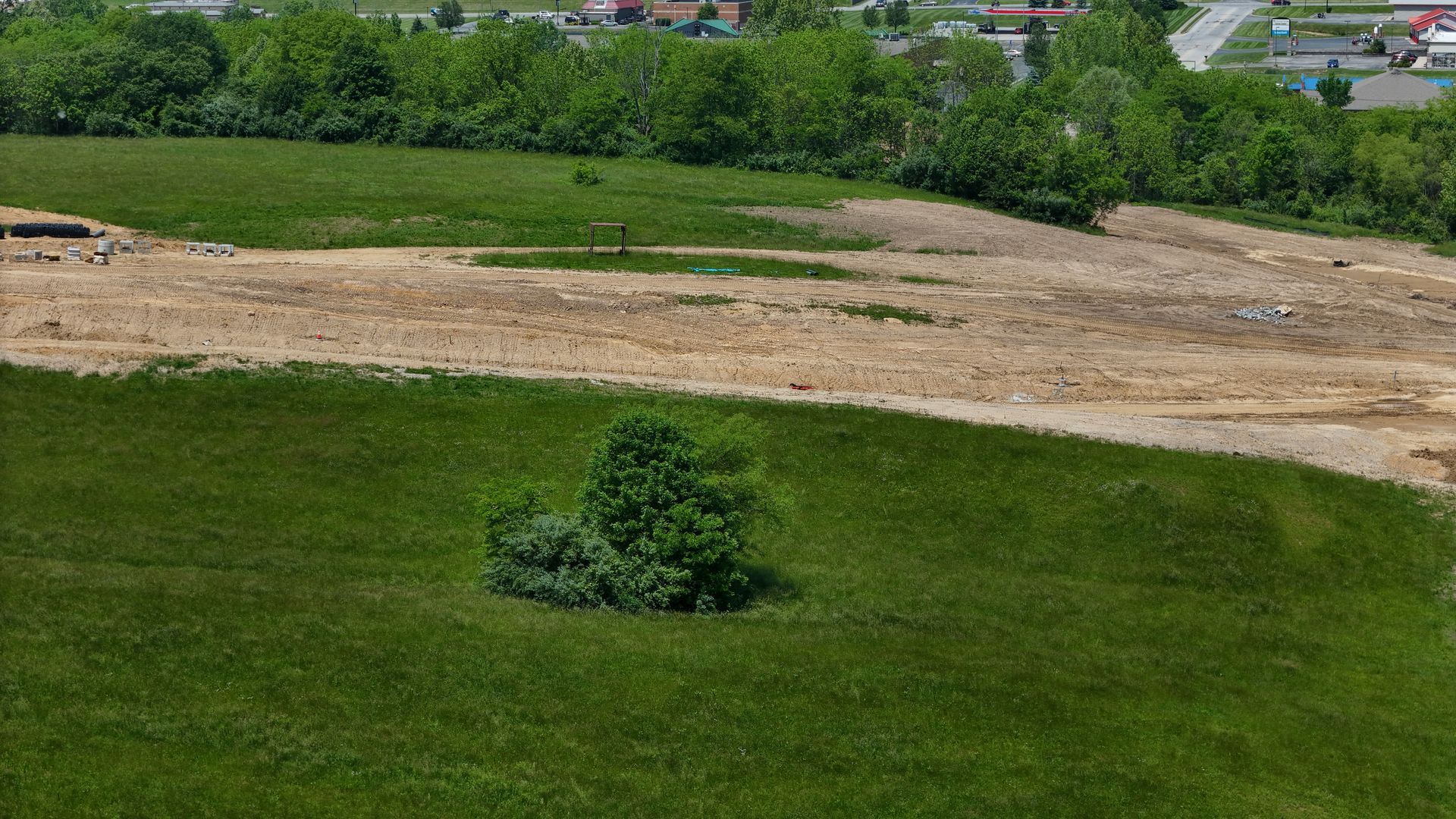
Job sites get a bird's-eye view thanks to these drones.
They're essential for getting a good look at the progress of construction.
Think of it as deploying highly detailed eyes in the sky, operated by certified drone pilots.
Drone services handle everything.
They plan the flights, fly the drones, and even sort through all the information the drones collect.
Accurate site maps, detailed 3D models, and thorough inspection reports?
Yep, they make all that happen, starting with raw data.
The drones used can vary based on the task.
Quadcopters excel at detailed inspections and navigating confined spaces, while fixed-wing drones efficiently cover large areas for initial site surveys.
Imagine having a bird's-eye view of a construction site—that's what advanced sensors give us.
They paint a clear picture of the site's operations and progress.
Why Construction Sites Need Drones
Is this just another technological trend?
Construction's persistent problems?
Drones are helping to fix them.
Effectively and safely managing large construction projects has always been demanding.
Traditional methods for surveying, inspection, and monitoring progress can be slow, costly, and occasionally hazardous for personnel.
These essential jobs are handled more effectively with construction drones, which means faster completion times and fewer human errors.
Drone technology is getting really useful - here's why.
Improving Site Safety
Safety remains paramount on any construction site.
Inspecting tough spots is safer with construction drones.
These helpful tools check dangerous places, so people don't have to.
That means making sure scaffolding is stable, giving roofs a good once-over, and thoroughly checking bridges.
No worker will be put in harm's way.
Imagine evaluating structural elements high above the ground without requiring personnel to climb, relying instead on clear drone photos.
Drones equipped with high-resolution cameras easily spot potential structural weaknesses or hazards.
A proactive approach to safety means finding and fixing problems *before* accidents happen.
This is crucial for building safer work environments that meet OSHA's standards for the construction industry.
Failing to do so can lead to serious consequences, including injuries and fines.
This is not only important for worker safety but also legally required.
Regular drone checks help us keep a close eye on things, spotting safety hazards or if anyone's cutting corners.
Safety managers can find potential problems quickly using this overview; it's much faster than doing a manual walkthrough.
Consistent site monitoring directly impacts and enhances safety standards; proactive oversight is crucial for maintaining a secure environment.
Boosting Efficiency and Speed
Time translates directly to cost in construction.
Drones significantly accelerate processes that previously consumed days or weeks.
For example, traditional land surveying is often labor-intensive and slow.
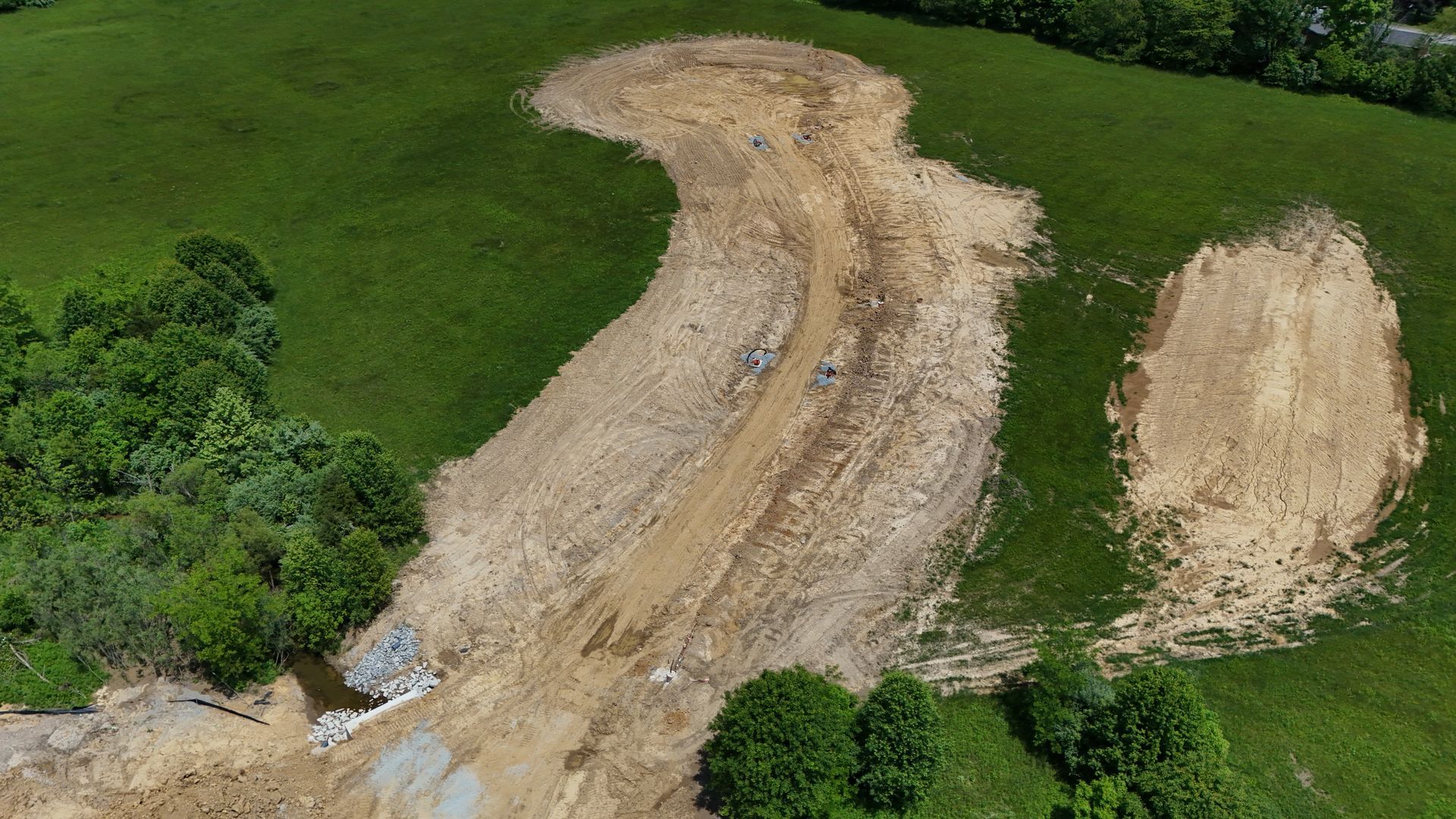
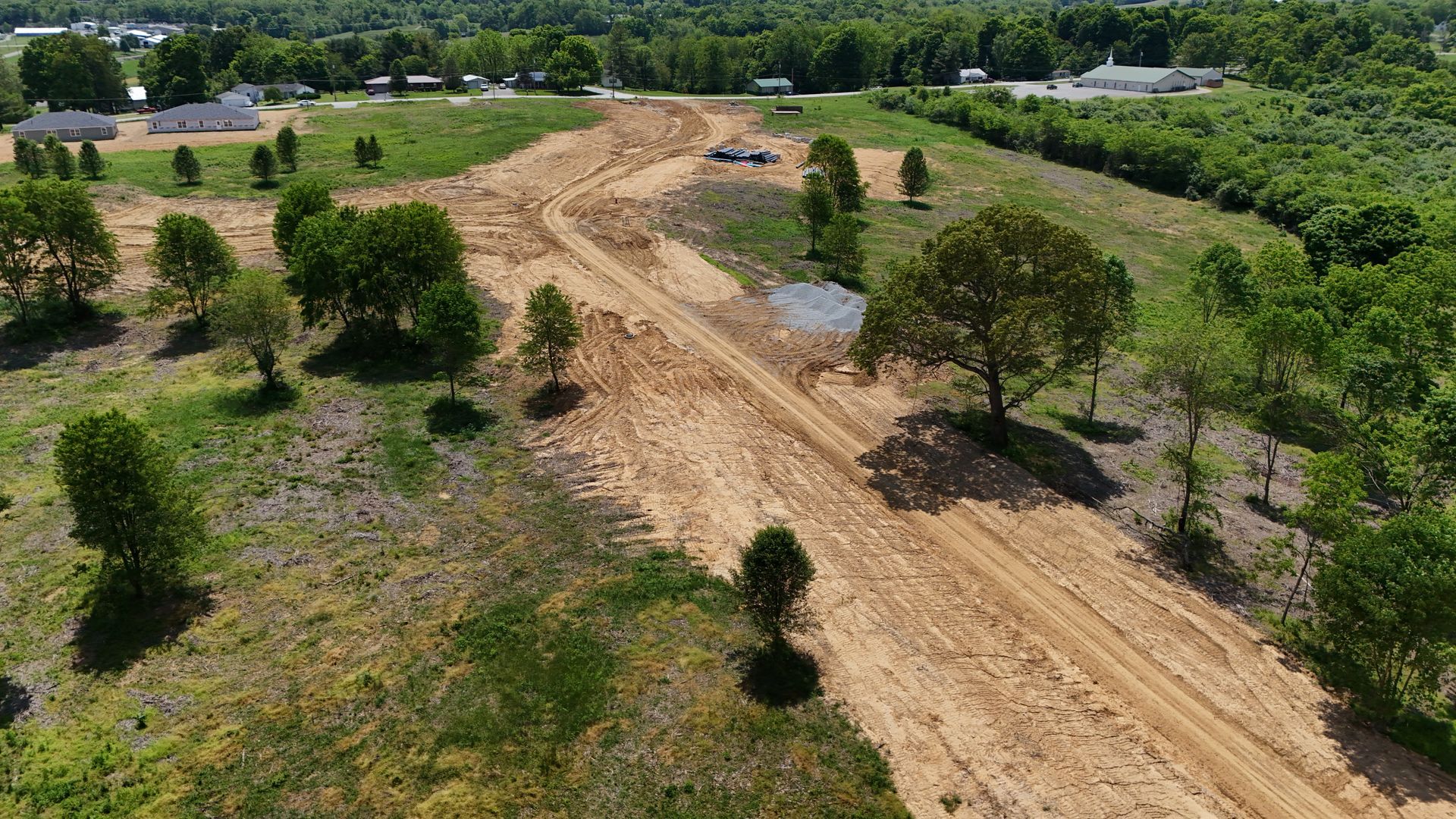
A construction drone surveys a large area, gathering topographic data.
In a matter of hours, you have perfect site maps and models.
Because of this speed boost, building projects can get going sooner and easily handle any adjustments needed from the aerial images.
The approval process can also be expedited with clear visual evidence.
Progress monitoring becomes far more efficient and transparent.
Instead of relying only on ground-level photos or periodic reports, drones provide a complete visual update regularly, often presented as drone video or sequences of aerial photos.
General contractors and the project team gain immediate insight into site progress across the entire job site, almost in real-time, making it easier to track progress.
Cutting Down Costs
While adopting drone services requires an initial investment, the return frequently manifests through significant cost savings.
Automated progress tracking eliminates lots of manual verification, and quicker surveys mean fewer labor hours.
Less time spent, fewer things to buy — it's a win-win!
Identifying design clashes or construction errors early via drone data prevents costly rework down the line.
Consider detecting a foundation discrepancy from drone footage before subsequent layers are built.
This early detection saves substantial money and avoids schedule disruptions.
Projects finish faster with better teamwork.
Simple as that.
Managing your stock more effectively saves you cash.
Accurately measuring material volumes on-site prevents over-ordering and allows for efficient tracking of usage.
Drones provide precise measurements, leading to cost savings in two key areas:
earthmoving and
materials.
Think of it like this: precise measurements mean less waste.
Key Applications of Construction Drone Service
The adaptability of drones allows for their use in numerous capacities throughout a construction project's lifecycle.
Starting with the first site visit and ending with the final paperwork, they hand over valuable data.
Here are some primary applications of drone services in construction:
Surveying and Mapping
Drone surveying is a cornerstone application.
Drones capture numerous aerial images, which specialized software then stitches together.
This process creates detailed orthomosaic maps — essentially high-resolution, geometrically corrected aerial photos.
They also generate precise topographic maps and 3D site models, sometimes referred to as a digital twin of the physical site.
Good site planning, accurate earthwork calculations, and design checks against existing conditions all depend on this information.
Compared to older ground-based methods, drone surveying provides faster and often more accurate site mapping across large or complex terrains through comprehensive site capture.
Early in a construction project, accurate information is critical.
These mapping services provide that data - without them, progress is much slower.
Good data gives planners and engineers the exact site information they need.
Fewer errors pop up during design and planning thanks to this accuracy.
Drone Applications and Benefits in Construction
| Application | Description | Key Benefits |
|---|---|---|
| Surveying & Site Mapping | Creating orthomosaics, topographic maps, 3D models, and digital twins from aerial data. Capturing existing conditions accurately. | Speed, Accuracy, Cost Savings, Comprehensive Site Data, Foundation for Planning. |
| Progress Monitoring & Reporting | Regular flights to document site progress with drone photos, drone video, and time-lapse sequences. Comparing as-built status to schedule/design. | Efficiency, Transparency, Early Issue Detection, Improved Communication, Progress Tracking. |
| Site Inspections | Detailed visual and thermal inspection of structures like roofs, facades, bridges, and utilities without manual access. Performing inspection site mapping. | Safety, Speed, Thoroughness, Cost Reduction, Access to Difficult Areas (e.g., roof inspection). |
| Volume Calculations | Using photogrammetry to accurately measure stockpile volumes (earthwork, aggregates) from drone data capture. | Accuracy, Speed, Improved Inventory Management, Cost Control for Materials. |
| Asset Management | Locating and inventorying equipment and materials across large job sites using regular aerial photos. | Organization, Loss Prevention, Time Savings, Site Overview. |
| Cost | High labor costs, potential lift rental | Lower operational costs, faster completion |
Progress Monitoring and Reporting
Keeping stakeholders informed is streamlined with drone data.
Regular flights capture compelling visual evidence of construction progress.
This drone footage can be shared through high-quality drone photos, informative drone video compilations, or even interactive 3D models accessible online.
Imagine providing a weekly drone-generated overview or a dynamic time-lapse video to clients and the project team instead of static ground photos.
Transparency is key!
It fosters trust and ensures everyone's on the same page regarding project updates.
This keeps things running smoothly.
The captured data can also be overlaid onto project schedules and Building Information Models (BIM) to objectively monitor progress and performance.
Sophisticated software tools analyze drone imagery to automatically measure progress on specific construction elements.
Keeping projects on schedule is easier with this; it highlights possible roadblocks early in the process.
Sharing progress updates via internal platforms or even selected clips on social media can also showcase advancements to prospective clients.
Site Inspections
Drones are exceptionally suited for detailed site inspections.
Getting up close to buildings is easy.
No expensive lifts or dangerous scaffolding are needed.
Inspecting building facades, roofs, bridges, and other infrastructure is easy with this.
Utilizing high-resolution cameras, certified drone pilots performing inspection surveying can easily spot cracks, defects, wear, or installation issues.
Thermal cameras on drones are another powerful tool for diagnosis.
Hidden problems, such as water damage, faulty insulation, or electrical problems, show up as temperature differences that the system detects.
It's faster and safer to use this inspection method; plus, you'll usually find more.
Quality control gets a boost during construction, and planning for upkeep after the project is finished is much simpler.
Inspection site mapping and assessment just got a major upgrade.
Volume Calculations
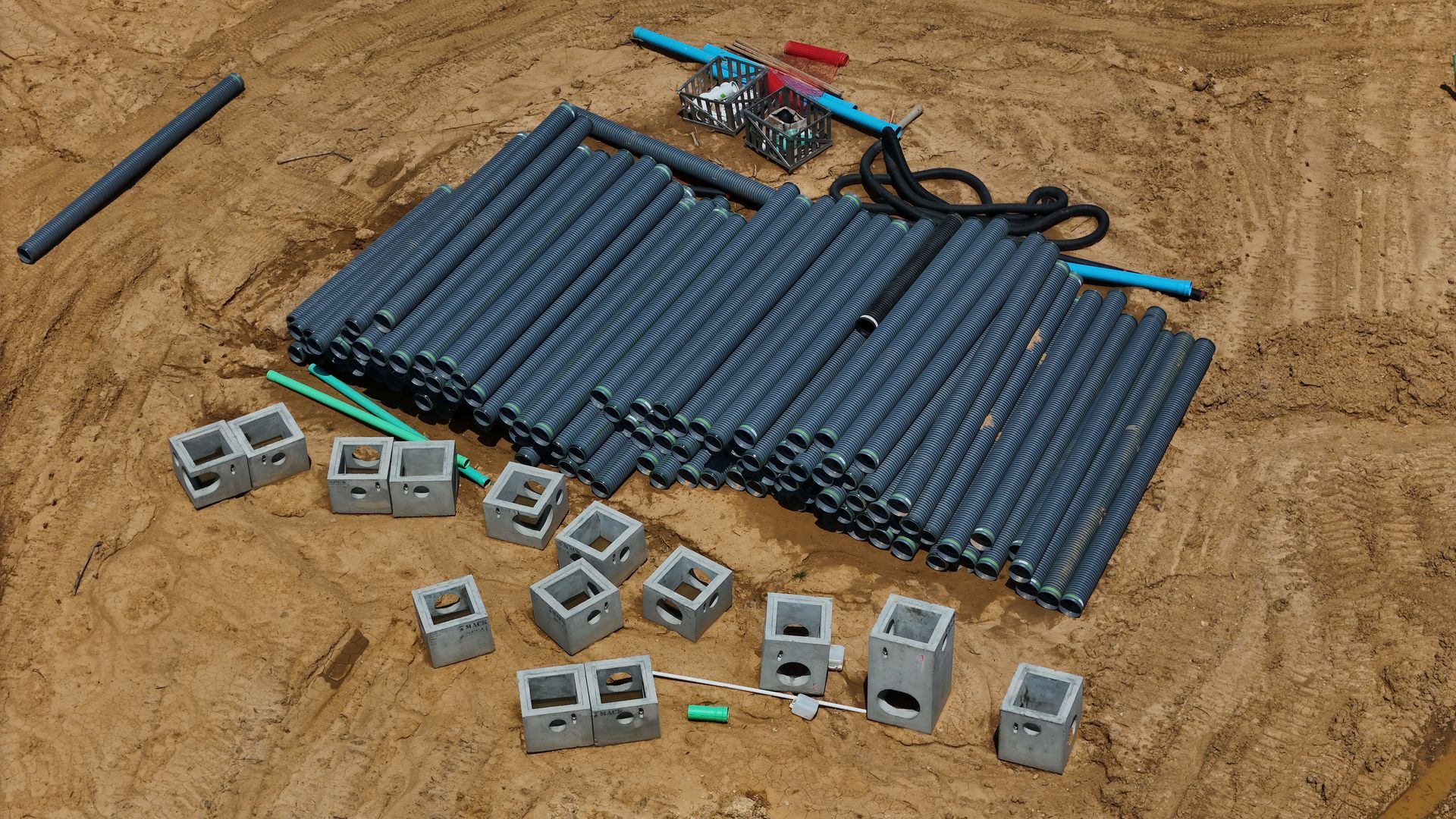
Accurately measuring stockpile volumes, such as soil, sand, gravel, or demolition debris, is crucial for managing earthworks and materials effectively.
Using drones, the task becomes simple and highly precise.
Software crunches the numbers from detailed aerial photos to give very precise volume measurements.
Forget those old estimating methods; this approach uses a faster, less manual process.
Knowing exactly how much you have helps contractors keep their supplies in order.
It gets the billing right for earthmoving work and materials used.
The speed of drone-based measurements means stockpiles can be monitored frequently, weekly, or even daily if needed.
Better logistics planning and tighter cost controls are now possible thanks to real-time data available to managers.
Precise measurements from drones?
That's how you stick to your budget.
Asset Management
Large construction sites often feature valuable equipment and materials dispersed across extensive areas.
Accurate inventory and asset location tracking: a difficult task requiring careful planning and execution, especially in larger organizations with numerous assets spread across multiple locations.
Think of a large hospital trying to track all its equipment!
Drones give us a great view of the whole construction site.
They take pictures regularly from above.
Managers can use these great aerial shots to quickly locate specific machinery, track material deliveries, or assess site layout.
Some advanced systems incorporate image recognition technology to automatically identify and inventory visible assets from the air.
Finding stuff is easier with a well-organized site, saving time and preventing losses.
Choosing the Right Construction Drone Service Provider
Not all companies that provide drone services possess the same qualifications or capabilities.
Partnering effectively is crucial for success with drones - it's all about getting the most bang for your buck.
Think of it like this: the right partner will make all the difference in maximizing the advantages of drone technology.
Here are key factors to consider when choosing a provider:
Experience and Expertise
Seek a provider with a demonstrated understanding of the construction industry.
Knowing the ins and outs of construction — the challenges, the lingo, and the way things operate — is essential.
Inquire about their track record with similar construction projects.
Before you hire, ask yourself:
Do they have a history of success with topographic mapping services?
Thermal inspections?
Digital twin creation?
This will save you headaches later on.
Checking out their past work, examples, and a quick demo will help you feel good about what they can do.
A provider knowledgeable about construction workflows will integrate more seamlessly with your project team.
Having worked with general contractors and across many industries is really useful.
Think real estate development or power plant construction — that kind of experience is beneficial.
Their drone pilots should be adept at capturing relevant data efficiently.
Licensing and Insurance
This aspect is critical and non-negotiable.
Commercial drone pilots operating in the US must hold a current FAA Part 107 Remote Pilot Certificate.
Confirm that the provider and all operating drone pilots possess the required certifications.
Inquire thoroughly about their insurance coverage.
Data breaches are also a real possibility with drones.
Make sure your company has insurance that covers this to protect your intellectual property (IP).
Adequate insurance protects your interests and your construction project against unforeseen accidents or operational mishaps.
Reputable providers are transparent about their credentials and insurance documentation.
Verification?
It brings a sense of calm.
They should adhere strictly to all airspace regulations.
Technology and Equipment
The quality of the final data capture hinges directly on the quality of the equipment used.
Ask detailed questions about the types of commercial drone platforms and sensors they employ.
High-resolution RGB cameras, LiDAR scanners (the survey-grade kind), and thermal cameras — do they have what you need?
See how good their data processing is.
Their software is professional grade, right?
Do they create accurate site maps, detailed 3D models, and complete reports with it?
They've got the technology to master construction data - this means high-quality outcomes.
It's that simple.
This equipment is perfect whether you need basic aerial photos or intricate survey work.
They should be able to provide drone options tailored to the job.
Their pilots capture data methodically for optimal processing.
Data Delivery and Integration
Clarify how you will receive the processed information.
Understand the formats of the deliverables (e.g., reports in PDF, image files like GeoTIFFs, point clouds in LAS format, 3D models as OBJ files).
Make sure the file formats are usable by your team and their programs.
Can you use your software with the drone data you collected?
Many construction firms rely heavily on project management suites (like Procore or Primavera) or BIM software (like Revit or Navisworks).
Drone data flows right into your existing systems, making it much more useful.
Think about data security: where you host it, the protocols for sharing, and the security steps you'll need.
These three aspects work together to ensure data protection.
Ask about the typical turnaround time from data capture to the final deliverable.
Drone services really take off when you have smooth data integration.
Construction Sites and Drones: The Future
Construction is about to change big time thanks to the fast improvements in drone technology.
Drones are becoming more automated, easily flying set paths all by themselves to gather the same data again and again.
Routine site checks are way more efficient now.
Artificial intelligence is changing things dramatically.
Analyzing drone photos, AI can detect construction defects, check project timelines, and identify potential hazards.
Material identification is another capability.
Say goodbye to slow, error-prone data analysis!
This integration makes it faster and provides much clearer results.
And get ready — drones may soon be doing physical labor at construction sites!
Researchers are investigating the use of large drones for moving small items, like tools and materials, to remote or difficult locations.
Think about building a bridge in a canyon — this could help a ton.
Think of how drones already help inspect power plants.
Soon, construction will see the same benefits.
Drones will become essential for everything from delivery to quality checks on the job site.
As drone laws change, it will change how we use drones, particularly when flying over crowds or too far to see.
The advancements in video technology and sensor capabilities are really going to improve things.
Think clearer images and more detailed data — the possibilities are endless.
Conclusion
Construction is changing thanks to drones.
Safety, efficiency, and cost savings are all improved when you use a professional construction drone service.
From start to finish, you get better control over your project.
Quick, safe, and accurate site data from drone services keeps construction projects on time and within budget.
It's a win-win for everyone involved, from project managers to investors.
From initial surveying and site mapping to final inspections and asset tracking, the applications are extensive and impactful.
Ready to view your project from new heights?
Contact 1st Choice Aerials today to schedule your aerial photography, inspection, or thermal imaging service!


